You are here: Home > Network List > TA - USArray Transportable Network (new EarthScope stations) Stations List
> Station 337A Centerville, TX, USA > Earthquake Result Viewer
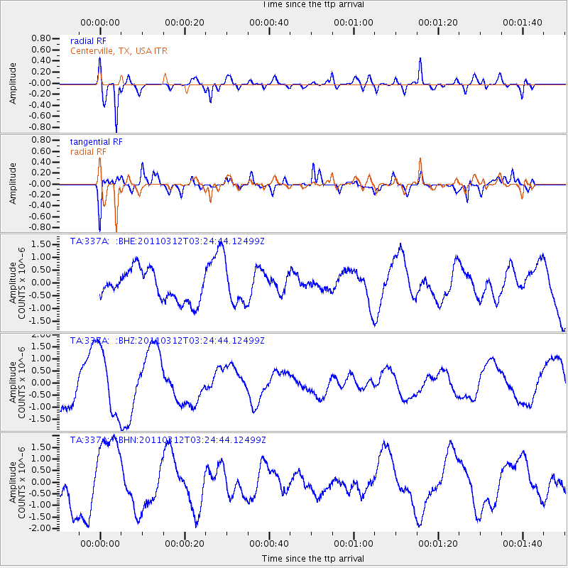
337A Centerville, TX, USA - Earthquake Result Viewer
*The percent match for this event was below the threshold and hence no stack was calculated.
| Earthquake location: |
Near East Coast Of Honshu, Japan |
| Earthquake latitude/longitude: |
36.0/141.3 |
| Earthquake time(UTC): |
2011/03/12 (071) 03:11:57 GMT |
| Earthquake Depth: |
17 km |
| Earthquake Magnitude: |
5.7 MB |
| Earthquake Catalog/Contributor: |
WHDF/NEIC |
|
| Network: |
TA USArray Transportable Network (new EarthScope stations) |
| Station: |
337A Centerville, TX, USA |
| Lat/Lon: |
31.32 N/95.89 W |
| Elevation: |
150 m |
|
| Distance: |
94.2 deg |
| Az: |
46.187 deg |
| Baz: |
316.836 deg |
| Ray Param: |
$rayparam |
*The percent match for this event was below the threshold and hence was not used in the summary stack. |
|
| Radial Match: |
81.85671 % |
| Radial Bump: |
400 |
| Transverse Match: |
71.23698 % |
| Transverse Bump: |
400 |
| SOD ConfigId: |
356183 |
| Insert Time: |
2011-08-19 13:25:16.253 +0000 |
| GWidth: |
2.5 |
| Max Bumps: |
400 |
| Tol: |
0.001 |
|
Signal To Noise
| Channel | StoN | STA | LTA |
| TA:337A: :BHZ:20110312T03:24:44.12499Z | 1.6235987 | 1.3521613E-6 | 8.328174E-7 |
| TA:337A: :BHN:20110312T03:24:44.12499Z | 2.3588152 | 1.7038105E-6 | 7.2231626E-7 |
| TA:337A: :BHE:20110312T03:24:44.12499Z | 1.3313279 | 7.66959E-7 | 5.760857E-7 |
| Arrivals |
| Ps | |
| PpPs | |
| PsPs/PpSs | |


