You are here: Home > Network List > TA - USArray Transportable Network (new EarthScope stations) Stations List
> Station V38A Canehill, AR, USA > Earthquake Result Viewer
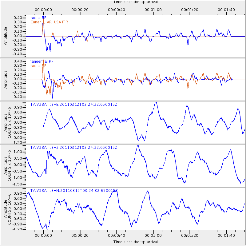
V38A Canehill, AR, USA - Earthquake Result Viewer
*The percent match for this event was below the threshold and hence no stack was calculated.
| Earthquake location: |
Near East Coast Of Honshu, Japan |
| Earthquake latitude/longitude: |
36.0/141.3 |
| Earthquake time(UTC): |
2011/03/12 (071) 03:11:57 GMT |
| Earthquake Depth: |
17 km |
| Earthquake Magnitude: |
5.7 MB |
| Earthquake Catalog/Contributor: |
WHDF/NEIC |
|
| Network: |
TA USArray Transportable Network (new EarthScope stations) |
| Station: |
V38A Canehill, AR, USA |
| Lat/Lon: |
35.86 N/94.41 W |
| Elevation: |
372 m |
|
| Distance: |
91.7 deg |
| Az: |
42.202 deg |
| Baz: |
317.856 deg |
| Ray Param: |
$rayparam |
*The percent match for this event was below the threshold and hence was not used in the summary stack. |
|
| Radial Match: |
49.311237 % |
| Radial Bump: |
400 |
| Transverse Match: |
59.269447 % |
| Transverse Bump: |
400 |
| SOD ConfigId: |
356183 |
| Insert Time: |
2011-08-19 13:29:35.180 +0000 |
| GWidth: |
2.5 |
| Max Bumps: |
400 |
| Tol: |
0.001 |
|
Signal To Noise
| Channel | StoN | STA | LTA |
| TA:V38A: :BHZ:20110312T03:24:32.650015Z | 1.572439 | 6.909361E-7 | 4.394041E-7 |
| TA:V38A: :BHN:20110312T03:24:32.650015Z | 2.6857817 | 1.0757565E-6 | 4.005376E-7 |
| TA:V38A: :BHE:20110312T03:24:32.650015Z | 0.63103867 | 2.1669263E-7 | 3.433904E-7 |
| Arrivals |
| Ps | |
| PpPs | |
| PsPs/PpSs | |


