You are here: Home > Network List > TA - USArray Transportable Network (new EarthScope stations) Stations List
> Station E34A Wadena, MN, USA > Earthquake Result Viewer
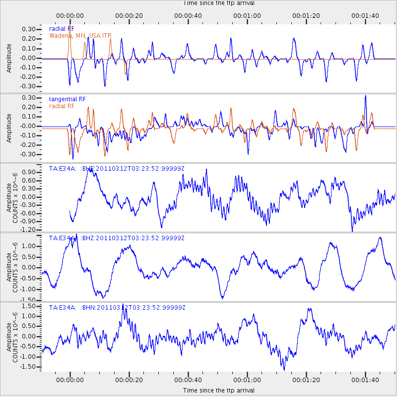
E34A Wadena, MN, USA - Earthquake Result Viewer
*The percent match for this event was below the threshold and hence no stack was calculated.
| Earthquake location: |
Near East Coast Of Honshu, Japan |
| Earthquake latitude/longitude: |
36.0/141.3 |
| Earthquake time(UTC): |
2011/03/12 (071) 03:11:57 GMT |
| Earthquake Depth: |
17 km |
| Earthquake Magnitude: |
5.7 MB |
| Earthquake Catalog/Contributor: |
WHDF/NEIC |
|
| Network: |
TA USArray Transportable Network (new EarthScope stations) |
| Station: |
E34A Wadena, MN, USA |
| Lat/Lon: |
46.51 N/95.17 W |
| Elevation: |
430 m |
|
| Distance: |
83.5 deg |
| Az: |
35.432 deg |
| Baz: |
317.07 deg |
| Ray Param: |
$rayparam |
*The percent match for this event was below the threshold and hence was not used in the summary stack. |
|
| Radial Match: |
68.156975 % |
| Radial Bump: |
400 |
| Transverse Match: |
51.211037 % |
| Transverse Bump: |
400 |
| SOD ConfigId: |
356183 |
| Insert Time: |
2011-08-19 13:34:44.023 +0000 |
| GWidth: |
2.5 |
| Max Bumps: |
400 |
| Tol: |
0.001 |
|
Signal To Noise
| Channel | StoN | STA | LTA |
| TA:E34A: :BHZ:20110312T03:23:52.99999Z | 2.5768714 | 1.0661624E-6 | 4.1374298E-7 |
| TA:E34A: :BHN:20110312T03:23:52.99999Z | 0.7139243 | 3.0464278E-7 | 4.267158E-7 |
| TA:E34A: :BHE:20110312T03:23:52.99999Z | 1.1962091 | 5.9098943E-7 | 4.940519E-7 |
| Arrivals |
| Ps | |
| PpPs | |
| PsPs/PpSs | |


