You are here: Home > Network List > TA - USArray Transportable Network (new EarthScope stations) Stations List
> Station O37A Wolven Farm, McFall, MO, USA > Earthquake Result Viewer
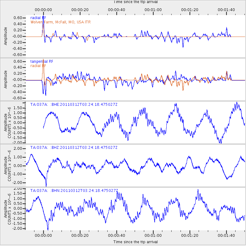
O37A Wolven Farm, McFall, MO, USA - Earthquake Result Viewer
*The percent match for this event was below the threshold and hence no stack was calculated.
| Earthquake location: |
Near East Coast Of Honshu, Japan |
| Earthquake latitude/longitude: |
36.0/141.3 |
| Earthquake time(UTC): |
2011/03/12 (071) 03:11:57 GMT |
| Earthquake Depth: |
17 km |
| Earthquake Magnitude: |
5.7 MB |
| Earthquake Catalog/Contributor: |
WHDF/NEIC |
|
| Network: |
TA USArray Transportable Network (new EarthScope stations) |
| Station: |
O37A Wolven Farm, McFall, MO, USA |
| Lat/Lon: |
40.17 N/94.15 W |
| Elevation: |
284 m |
|
| Distance: |
88.7 deg |
| Az: |
39.17 deg |
| Baz: |
318.027 deg |
| Ray Param: |
$rayparam |
*The percent match for this event was below the threshold and hence was not used in the summary stack. |
|
| Radial Match: |
62.857197 % |
| Radial Bump: |
400 |
| Transverse Match: |
32.406124 % |
| Transverse Bump: |
400 |
| SOD ConfigId: |
356183 |
| Insert Time: |
2011-08-19 13:41:44.635 +0000 |
| GWidth: |
2.5 |
| Max Bumps: |
400 |
| Tol: |
0.001 |
|
Signal To Noise
| Channel | StoN | STA | LTA |
| TA:O37A: :BHZ:20110312T03:24:18.475027Z | 2.2464013 | 1.1460679E-6 | 5.101796E-7 |
| TA:O37A: :BHN:20110312T03:24:18.475027Z | 3.9936705 | 1.0371853E-6 | 2.5970726E-7 |
| TA:O37A: :BHE:20110312T03:24:18.475027Z | 1.3654512 | 9.787002E-7 | 7.1675953E-7 |
| Arrivals |
| Ps | |
| PpPs | |
| PsPs/PpSs | |


