You are here: Home > Network List > IC - New China Digital Seismograph Network Stations List
> Station ENH Enshi, Hubei Province, China > Earthquake Result Viewer
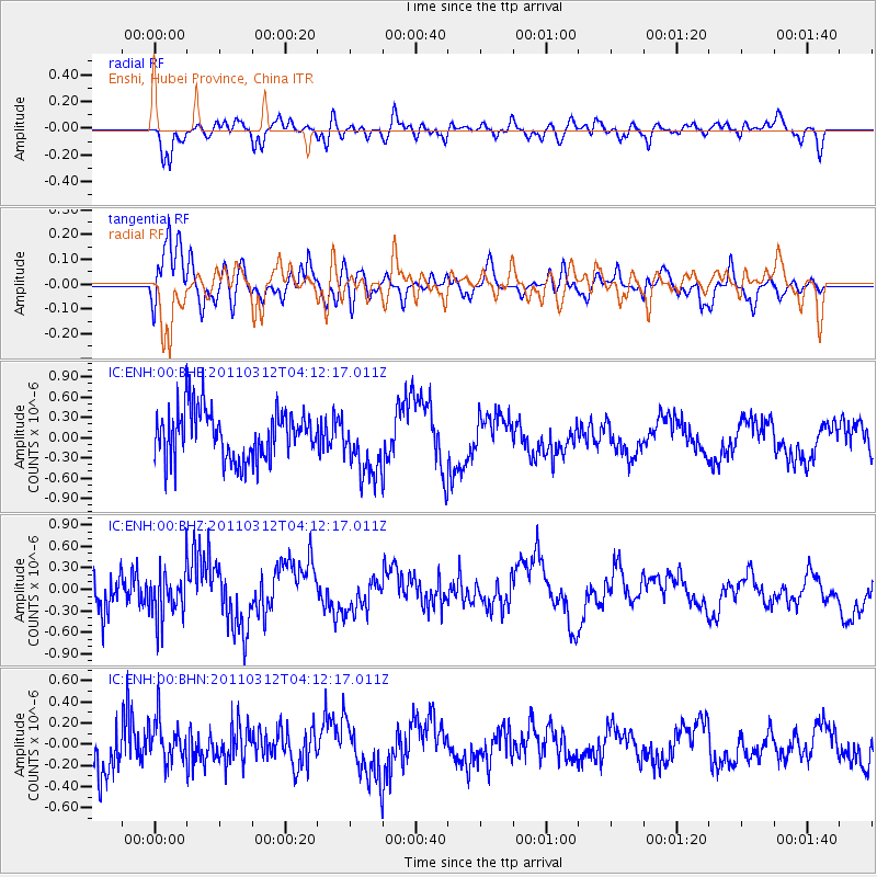
ENH Enshi, Hubei Province, China - Earthquake Result Viewer
*The percent match for this event was below the threshold and hence no stack was calculated.
| Earthquake location: |
Irian Jaya, Indonesia |
| Earthquake latitude/longitude: |
-3.0/139.1 |
| Earthquake time(UTC): |
2011/03/12 (071) 04:04:49 GMT |
| Earthquake Depth: |
59 km |
| Earthquake Magnitude: |
5.5 MB |
| Earthquake Catalog/Contributor: |
WHDF/NEIC |
|
| Network: |
IC New China Digital Seismograph Network |
| Station: |
ENH Enshi, Hubei Province, China |
| Lat/Lon: |
30.28 N/109.49 E |
| Elevation: |
500 m |
|
| Distance: |
43.5 deg |
| Az: |
321.655 deg |
| Baz: |
134.26 deg |
| Ray Param: |
$rayparam |
*The percent match for this event was below the threshold and hence was not used in the summary stack. |
|
| Radial Match: |
62.118275 % |
| Radial Bump: |
400 |
| Transverse Match: |
76.41109 % |
| Transverse Bump: |
400 |
| SOD ConfigId: |
356183 |
| Insert Time: |
2011-08-19 14:07:02.992 +0000 |
| GWidth: |
2.5 |
| Max Bumps: |
400 |
| Tol: |
0.001 |
|
Signal To Noise
| Channel | StoN | STA | LTA |
| IC:ENH:00:BHZ:20110312T04:12:17.011Z | 0.815198 | 3.5688063E-7 | 4.37784E-7 |
| IC:ENH:00:BHN:20110312T04:12:17.011Z | 0.89667803 | 2.0913487E-7 | 2.3323295E-7 |
| IC:ENH:00:BHE:20110312T04:12:17.011Z | 1.2541733 | 4.6410307E-7 | 3.7004702E-7 |
| Arrivals |
| Ps | |
| PpPs | |
| PsPs/PpSs | |


