You are here: Home > Network List > TA - USArray Transportable Network (new EarthScope stations) Stations List
> Station 535A Dale, TX, USA > Earthquake Result Viewer
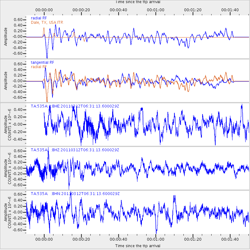
535A Dale, TX, USA - Earthquake Result Viewer
*The percent match for this event was below the threshold and hence no stack was calculated.
| Earthquake location: |
Near East Coast Of Honshu, Japan |
| Earthquake latitude/longitude: |
39.2/142.3 |
| Earthquake time(UTC): |
2011/03/12 (071) 06:18:44 GMT |
| Earthquake Depth: |
54 km |
| Earthquake Magnitude: |
5.5 MB |
| Earthquake Catalog/Contributor: |
WHDF/NEIC |
|
| Network: |
TA USArray Transportable Network (new EarthScope stations) |
| Station: |
535A Dale, TX, USA |
| Lat/Lon: |
30.03 N/97.57 W |
| Elevation: |
170 m |
|
| Distance: |
91.4 deg |
| Az: |
48.635 deg |
| Baz: |
317.722 deg |
| Ray Param: |
$rayparam |
*The percent match for this event was below the threshold and hence was not used in the summary stack. |
|
| Radial Match: |
65.58803 % |
| Radial Bump: |
400 |
| Transverse Match: |
65.476555 % |
| Transverse Bump: |
400 |
| SOD ConfigId: |
356183 |
| Insert Time: |
2011-08-19 15:25:30.181 +0000 |
| GWidth: |
2.5 |
| Max Bumps: |
400 |
| Tol: |
0.001 |
|
Signal To Noise
| Channel | StoN | STA | LTA |
| TA:535A: :BHZ:20110312T06:31:13.600029Z | 2.3799682 | 2.3509052E-7 | 9.8778855E-8 |
| TA:535A: :BHN:20110312T06:31:13.600029Z | 1.4092257 | 2.1756661E-7 | 1.5438735E-7 |
| TA:535A: :BHE:20110312T06:31:13.600029Z | 0.91775465 | 1.941247E-7 | 2.1152134E-7 |
| Arrivals |
| Ps | |
| PpPs | |
| PsPs/PpSs | |


