You are here: Home > Network List > KN - Kyrgyz Seismic Telemetry Network Stations List
> Station TKM2 KN.TKM2 > Earthquake Result Viewer
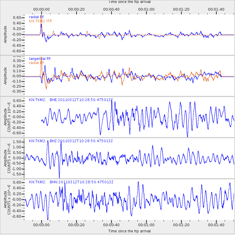
TKM2 KN.TKM2 - Earthquake Result Viewer
*The percent match for this event was below the threshold and hence no stack was calculated.
| Earthquake location: |
Off East Coast Of Honshu, Japan |
| Earthquake latitude/longitude: |
37.2/143.5 |
| Earthquake time(UTC): |
2011/03/12 (071) 10:20:21 GMT |
| Earthquake Depth: |
22 km |
| Earthquake Magnitude: |
5.5 MB, 5.3 MW |
| Earthquake Catalog/Contributor: |
WHDF/NEIC |
|
| Network: |
KN Kyrgyz Seismic Telemetry Network |
| Station: |
TKM2 KN.TKM2 |
| Lat/Lon: |
42.92 N/75.60 E |
| Elevation: |
2020 m |
|
| Distance: |
51.0 deg |
| Az: |
298.908 deg |
| Baz: |
72.208 deg |
| Ray Param: |
$rayparam |
*The percent match for this event was below the threshold and hence was not used in the summary stack. |
|
| Radial Match: |
62.81512 % |
| Radial Bump: |
348 |
| Transverse Match: |
62.182106 % |
| Transverse Bump: |
400 |
| SOD ConfigId: |
356183 |
| Insert Time: |
2011-08-19 16:58:08.193 +0000 |
| GWidth: |
2.5 |
| Max Bumps: |
400 |
| Tol: |
0.001 |
|
Signal To Noise
| Channel | StoN | STA | LTA |
| KN:TKM2: :BHZ:20110312T10:28:50.475013Z | 3.6664572 | 6.7654196E-7 | 1.84522E-7 |
| KN:TKM2: :BHN:20110312T10:28:50.475013Z | 2.013055 | 3.2441122E-7 | 1.6115368E-7 |
| KN:TKM2: :BHE:20110312T10:28:50.475013Z | 1.8315094 | 2.8622688E-7 | 1.5627924E-7 |
| Arrivals |
| Ps | |
| PpPs | |
| PsPs/PpSs | |


