You are here: Home > Network List > MN - MEDNET Project Stations List
> Station TIP Timpagrande, Italy > Earthquake Result Viewer
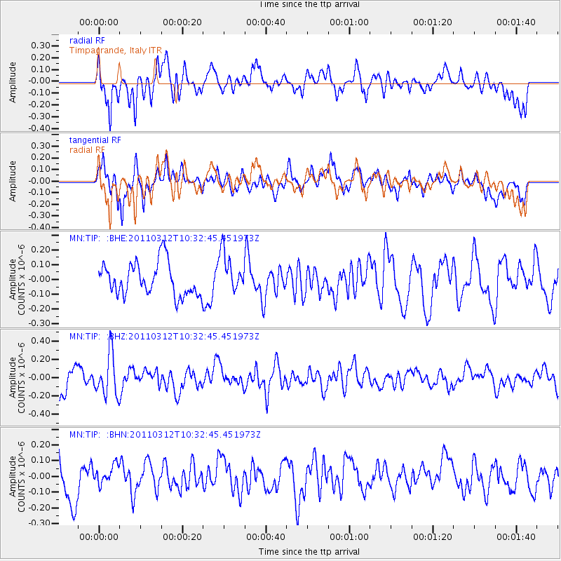
TIP Timpagrande, Italy - Earthquake Result Viewer
*The percent match for this event was below the threshold and hence no stack was calculated.
| Earthquake location: |
Off East Coast Of Honshu, Japan |
| Earthquake latitude/longitude: |
37.2/143.5 |
| Earthquake time(UTC): |
2011/03/12 (071) 10:20:21 GMT |
| Earthquake Depth: |
22 km |
| Earthquake Magnitude: |
5.5 MB, 5.3 MW |
| Earthquake Catalog/Contributor: |
WHDF/NEIC |
|
| Network: |
MN MEDNET Project |
| Station: |
TIP Timpagrande, Italy |
| Lat/Lon: |
39.18 N/16.76 E |
| Elevation: |
789 m |
|
| Distance: |
89.6 deg |
| Az: |
321.457 deg |
| Baz: |
39.832 deg |
| Ray Param: |
$rayparam |
*The percent match for this event was below the threshold and hence was not used in the summary stack. |
|
| Radial Match: |
63.063698 % |
| Radial Bump: |
400 |
| Transverse Match: |
67.7888 % |
| Transverse Bump: |
398 |
| SOD ConfigId: |
356183 |
| Insert Time: |
2011-08-19 17:02:31.447 +0000 |
| GWidth: |
2.5 |
| Max Bumps: |
400 |
| Tol: |
0.001 |
|
Signal To Noise
| Channel | StoN | STA | LTA |
| MN:TIP: :BHZ:20110312T10:32:45.451973Z | 2.0532284 | 2.3573246E-7 | 1.1481063E-7 |
| MN:TIP: :BHN:20110312T10:32:45.451973Z | 0.5494684 | 6.547978E-8 | 1.19169336E-7 |
| MN:TIP: :BHE:20110312T10:32:45.451973Z | 1.225816 | 1.361325E-7 | 1.1105459E-7 |
| Arrivals |
| Ps | |
| PpPs | |
| PsPs/PpSs | |


