You are here: Home > Network List > TA - USArray Transportable Network (new EarthScope stations) Stations List
> Station R31A Burdett, KS, USA > Earthquake Result Viewer
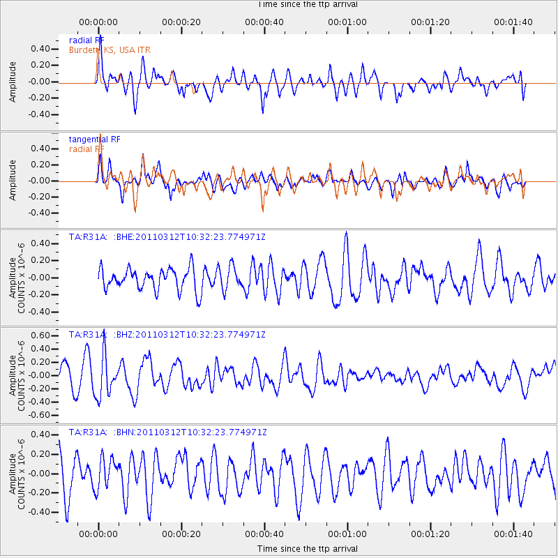
R31A Burdett, KS, USA - Earthquake Result Viewer
*The percent match for this event was below the threshold and hence no stack was calculated.
| Earthquake location: |
Off East Coast Of Honshu, Japan |
| Earthquake latitude/longitude: |
37.2/143.5 |
| Earthquake time(UTC): |
2011/03/12 (071) 10:20:21 GMT |
| Earthquake Depth: |
22 km |
| Earthquake Magnitude: |
5.5 MB, 5.3 MW |
| Earthquake Catalog/Contributor: |
WHDF/NEIC |
|
| Network: |
TA USArray Transportable Network (new EarthScope stations) |
| Station: |
R31A Burdett, KS, USA |
| Lat/Lon: |
38.29 N/99.53 W |
| Elevation: |
667 m |
|
| Distance: |
85.1 deg |
| Az: |
44.725 deg |
| Baz: |
314.397 deg |
| Ray Param: |
$rayparam |
*The percent match for this event was below the threshold and hence was not used in the summary stack. |
|
| Radial Match: |
53.280113 % |
| Radial Bump: |
400 |
| Transverse Match: |
50.911263 % |
| Transverse Bump: |
400 |
| SOD ConfigId: |
356183 |
| Insert Time: |
2011-08-19 17:13:14.250 +0000 |
| GWidth: |
2.5 |
| Max Bumps: |
400 |
| Tol: |
0.001 |
|
Signal To Noise
| Channel | StoN | STA | LTA |
| TA:R31A: :BHZ:20110312T10:32:23.774971Z | 2.703096 | 3.0214755E-7 | 1.1177834E-7 |
| TA:R31A: :BHN:20110312T10:32:23.774971Z | 0.7557593 | 1.5834705E-7 | 2.0952046E-7 |
| TA:R31A: :BHE:20110312T10:32:23.774971Z | 1.0847493 | 1.3557495E-7 | 1.2498273E-7 |
| Arrivals |
| Ps | |
| PpPs | |
| PsPs/PpSs | |


