You are here: Home > Network List > TA - USArray Transportable Network (new EarthScope stations) Stations List
> Station V38A Canehill, AR, USA > Earthquake Result Viewer
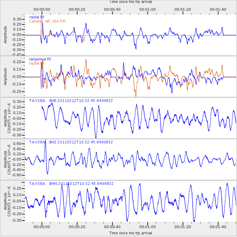
V38A Canehill, AR, USA - Earthquake Result Viewer
*The percent match for this event was below the threshold and hence no stack was calculated.
| Earthquake location: |
Off East Coast Of Honshu, Japan |
| Earthquake latitude/longitude: |
37.2/143.5 |
| Earthquake time(UTC): |
2011/03/12 (071) 10:20:21 GMT |
| Earthquake Depth: |
22 km |
| Earthquake Magnitude: |
5.5 MB, 5.3 MW |
| Earthquake Catalog/Contributor: |
WHDF/NEIC |
|
| Network: |
TA USArray Transportable Network (new EarthScope stations) |
| Station: |
V38A Canehill, AR, USA |
| Lat/Lon: |
35.86 N/94.41 W |
| Elevation: |
372 m |
|
| Distance: |
89.7 deg |
| Az: |
43.467 deg |
| Baz: |
317.415 deg |
| Ray Param: |
$rayparam |
*The percent match for this event was below the threshold and hence was not used in the summary stack. |
|
| Radial Match: |
55.851677 % |
| Radial Bump: |
400 |
| Transverse Match: |
42.895515 % |
| Transverse Bump: |
400 |
| SOD ConfigId: |
356183 |
| Insert Time: |
2011-08-19 17:33:14.132 +0000 |
| GWidth: |
2.5 |
| Max Bumps: |
400 |
| Tol: |
0.001 |
|
Signal To Noise
| Channel | StoN | STA | LTA |
| TA:V38A: :BHZ:20110312T10:32:45.849983Z | 2.346383 | 3.1434155E-7 | 1.3396854E-7 |
| TA:V38A: :BHN:20110312T10:32:45.849983Z | 0.9993286 | 1.0142576E-7 | 1.014939E-7 |
| TA:V38A: :BHE:20110312T10:32:45.849983Z | 1.7781366 | 2.2353382E-7 | 1.257124E-7 |
| Arrivals |
| Ps | |
| PpPs | |
| PsPs/PpSs | |


