You are here: Home > Network List > TA - USArray Transportable Network (new EarthScope stations) Stations List
> Station K31A O'Neill, NE, USA > Earthquake Result Viewer
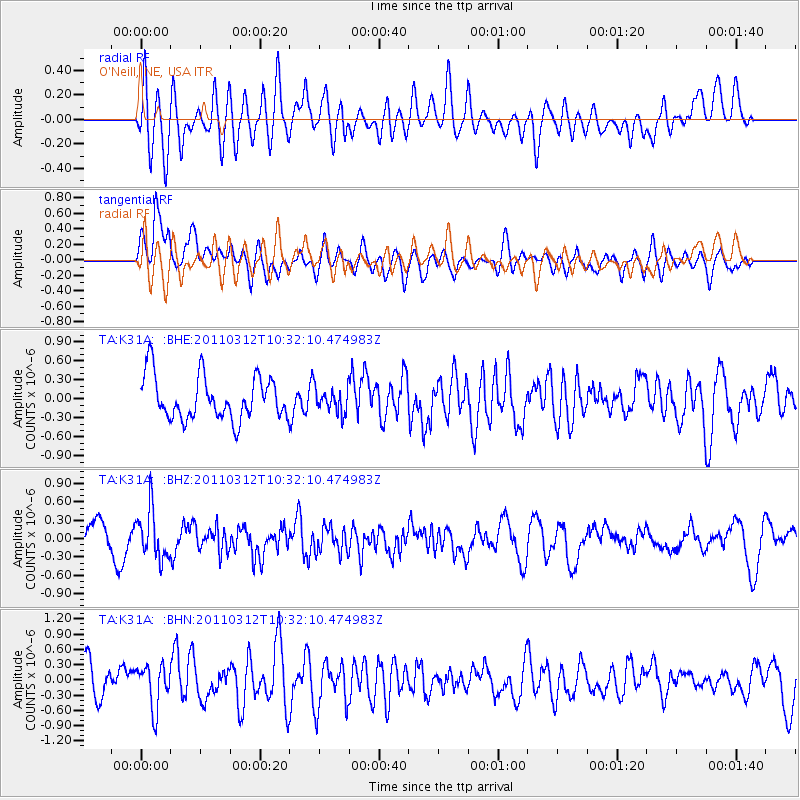
K31A O'Neill, NE, USA - Earthquake Result Viewer
*The percent match for this event was below the threshold and hence no stack was calculated.
| Earthquake location: |
Off East Coast Of Honshu, Japan |
| Earthquake latitude/longitude: |
37.2/143.5 |
| Earthquake time(UTC): |
2011/03/12 (071) 10:20:21 GMT |
| Earthquake Depth: |
22 km |
| Earthquake Magnitude: |
5.5 MB, 5.3 MW |
| Earthquake Catalog/Contributor: |
WHDF/NEIC |
|
| Network: |
TA USArray Transportable Network (new EarthScope stations) |
| Station: |
K31A O'Neill, NE, USA |
| Lat/Lon: |
42.62 N/98.75 W |
| Elevation: |
580 m |
|
| Distance: |
82.5 deg |
| Az: |
41.201 deg |
| Baz: |
314.515 deg |
| Ray Param: |
$rayparam |
*The percent match for this event was below the threshold and hence was not used in the summary stack. |
|
| Radial Match: |
63.62139 % |
| Radial Bump: |
400 |
| Transverse Match: |
69.23281 % |
| Transverse Bump: |
400 |
| SOD ConfigId: |
356183 |
| Insert Time: |
2011-08-19 17:39:07.798 +0000 |
| GWidth: |
2.5 |
| Max Bumps: |
400 |
| Tol: |
0.001 |
|
Signal To Noise
| Channel | StoN | STA | LTA |
| TA:K31A: :BHZ:20110312T10:32:10.474983Z | 2.0265975 | 4.006378E-7 | 1.9768986E-7 |
| TA:K31A: :BHN:20110312T10:32:10.474983Z | 1.7574959 | 4.229305E-7 | 2.406438E-7 |
| TA:K31A: :BHE:20110312T10:32:10.474983Z | 0.5434129 | 1.857723E-7 | 3.4186212E-7 |
| Arrivals |
| Ps | |
| PpPs | |
| PsPs/PpSs | |


