You are here: Home > Network List > TA - USArray Transportable Network (new EarthScope stations) Stations List
> Station R40A Maddie's Station, St. Elizabeth, MO, USA > Earthquake Result Viewer
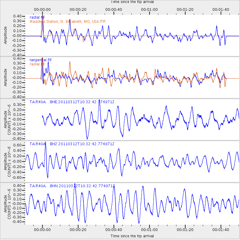
R40A Maddie's Station, St. Elizabeth, MO, USA - Earthquake Result Viewer
*The percent match for this event was below the threshold and hence no stack was calculated.
| Earthquake location: |
Off East Coast Of Honshu, Japan |
| Earthquake latitude/longitude: |
37.2/143.5 |
| Earthquake time(UTC): |
2011/03/12 (071) 10:20:21 GMT |
| Earthquake Depth: |
22 km |
| Earthquake Magnitude: |
5.5 MB, 5.3 MW |
| Earthquake Catalog/Contributor: |
WHDF/NEIC |
|
| Network: |
TA USArray Transportable Network (new EarthScope stations) |
| Station: |
R40A Maddie's Station, St. Elizabeth, MO, USA |
| Lat/Lon: |
38.29 N/92.27 W |
| Elevation: |
213 m |
|
| Distance: |
89.0 deg |
| Az: |
40.574 deg |
| Baz: |
318.667 deg |
| Ray Param: |
$rayparam |
*The percent match for this event was below the threshold and hence was not used in the summary stack. |
|
| Radial Match: |
49.801903 % |
| Radial Bump: |
400 |
| Transverse Match: |
51.945126 % |
| Transverse Bump: |
400 |
| SOD ConfigId: |
356183 |
| Insert Time: |
2011-08-19 17:47:14.415 +0000 |
| GWidth: |
2.5 |
| Max Bumps: |
400 |
| Tol: |
0.001 |
|
Signal To Noise
| Channel | StoN | STA | LTA |
| TA:R40A: :BHZ:20110312T10:32:42.774971Z | 2.5015857 | 3.173151E-7 | 1.2684559E-7 |
| TA:R40A: :BHN:20110312T10:32:42.774971Z | 1.003395 | 1.3547532E-7 | 1.3501693E-7 |
| TA:R40A: :BHE:20110312T10:32:42.774971Z | 1.6457639 | 1.6513583E-7 | 1.0033993E-7 |
| Arrivals |
| Ps | |
| PpPs | |
| PsPs/PpSs | |


