You are here: Home > Network List > CN - Canadian National Seismograph Network Stations List
> Station FRB Iqaluit, Nunavut Territory, Canada > Earthquake Result Viewer
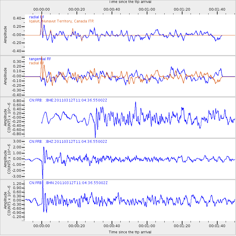
FRB Iqaluit, Nunavut Territory, Canada - Earthquake Result Viewer
*The percent match for this event was below the threshold and hence no stack was calculated.
| Earthquake location: |
Near East Coast Of Honshu, Japan |
| Earthquake latitude/longitude: |
39.0/142.3 |
| Earthquake time(UTC): |
2011/03/12 (071) 10:53:30 GMT |
| Earthquake Depth: |
27 km |
| Earthquake Magnitude: |
6.0 MB, 5.4 MS, 5.7 MW, 5.7 MW |
| Earthquake Catalog/Contributor: |
WHDF/NEIC |
|
| Network: |
CN Canadian National Seismograph Network |
| Station: |
FRB Iqaluit, Nunavut Territory, Canada |
| Lat/Lon: |
63.75 N/68.55 W |
| Elevation: |
25 m |
|
| Distance: |
74.7 deg |
| Az: |
13.668 deg |
| Baz: |
335.56 deg |
| Ray Param: |
$rayparam |
*The percent match for this event was below the threshold and hence was not used in the summary stack. |
|
| Radial Match: |
66.85075 % |
| Radial Bump: |
400 |
| Transverse Match: |
66.735504 % |
| Transverse Bump: |
400 |
| SOD ConfigId: |
356183 |
| Insert Time: |
2011-08-19 18:25:07.532 +0000 |
| GWidth: |
2.5 |
| Max Bumps: |
400 |
| Tol: |
0.001 |
|
Signal To Noise
| Channel | StoN | STA | LTA |
| CN:FRB: :BHZ:20110312T11:04:36.55002Z | 5.7519445 | 1.0808083E-6 | 1.8790311E-7 |
| CN:FRB: :BHN:20110312T11:04:36.55002Z | 3.0309427 | 4.9310563E-7 | 1.6269051E-7 |
| CN:FRB: :BHE:20110312T11:04:36.55002Z | 2.54719 | 3.792328E-7 | 1.488828E-7 |
| Arrivals |
| Ps | |
| PpPs | |
| PsPs/PpSs | |


