You are here: Home > Network List > IC - New China Digital Seismograph Network Stations List
> Station KMI Kunming, Yunnan Province, China > Earthquake Result Viewer
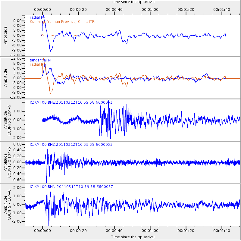
KMI Kunming, Yunnan Province, China - Earthquake Result Viewer
*The percent match for this event was below the threshold and hence no stack was calculated.
| Earthquake location: |
Near East Coast Of Honshu, Japan |
| Earthquake latitude/longitude: |
39.0/142.3 |
| Earthquake time(UTC): |
2011/03/12 (071) 10:53:30 GMT |
| Earthquake Depth: |
27 km |
| Earthquake Magnitude: |
6.0 MB, 5.4 MS, 5.7 MW, 5.7 MW |
| Earthquake Catalog/Contributor: |
WHDF/NEIC |
|
| Network: |
IC New China Digital Seismograph Network |
| Station: |
KMI Kunming, Yunnan Province, China |
| Lat/Lon: |
25.12 N/102.74 E |
| Elevation: |
1975 m |
|
| Distance: |
36.0 deg |
| Az: |
259.223 deg |
| Baz: |
57.549 deg |
| Ray Param: |
$rayparam |
*The percent match for this event was below the threshold and hence was not used in the summary stack. |
|
| Radial Match: |
68.59645 % |
| Radial Bump: |
400 |
| Transverse Match: |
53.892204 % |
| Transverse Bump: |
400 |
| SOD ConfigId: |
356183 |
| Insert Time: |
2011-08-19 18:29:21.408 +0000 |
| GWidth: |
2.5 |
| Max Bumps: |
400 |
| Tol: |
0.001 |
|
Signal To Noise
| Channel | StoN | STA | LTA |
| IC:KMI:00:BHZ:20110312T10:59:58.660005Z | 5.4634066 | 2.1254847E-7 | 3.8904016E-8 |
| IC:KMI:00:BHN:20110312T10:59:58.660005Z | 3.6867726 | 8.143158E-7 | 2.2087497E-7 |
| IC:KMI:00:BHE:20110312T10:59:58.660005Z | 3.0399702 | 7.776721E-7 | 2.5581568E-7 |
| Arrivals |
| Ps | |
| PpPs | |
| PsPs/PpSs | |


