You are here: Home > Network List > TA - USArray Transportable Network (new EarthScope stations) Stations List
> Station Q31A Ellis, KS, USA > Earthquake Result Viewer
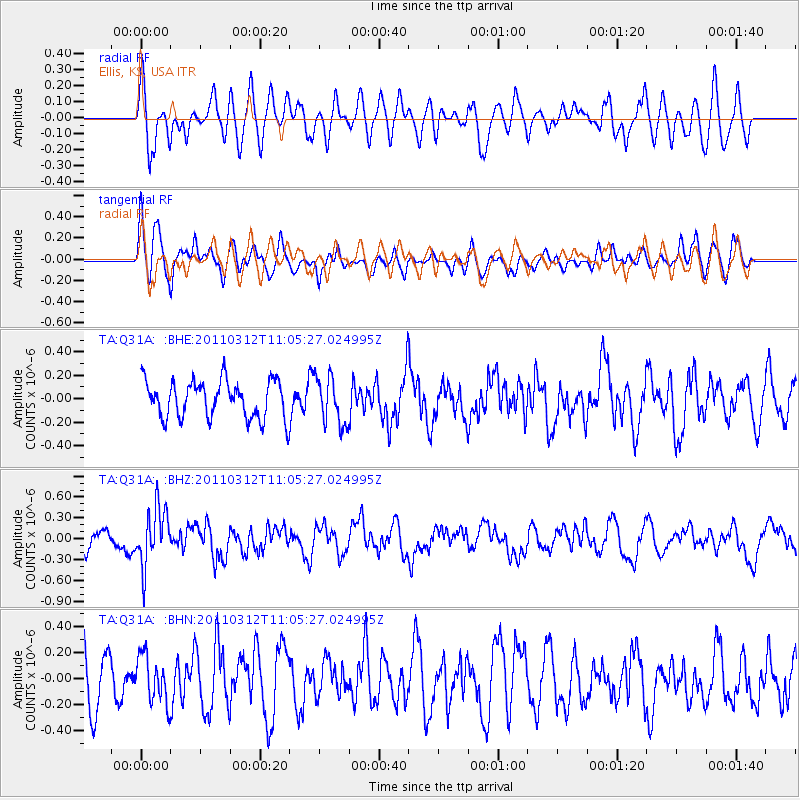
Q31A Ellis, KS, USA - Earthquake Result Viewer
*The percent match for this event was below the threshold and hence no stack was calculated.
| Earthquake location: |
Near East Coast Of Honshu, Japan |
| Earthquake latitude/longitude: |
39.0/142.3 |
| Earthquake time(UTC): |
2011/03/12 (071) 10:53:30 GMT |
| Earthquake Depth: |
27 km |
| Earthquake Magnitude: |
6.0 MB, 5.4 MS, 5.7 MW, 5.7 MW |
| Earthquake Catalog/Contributor: |
WHDF/NEIC |
|
| Network: |
TA USArray Transportable Network (new EarthScope stations) |
| Station: |
Q31A Ellis, KS, USA |
| Lat/Lon: |
39.00 N/99.39 W |
| Elevation: |
680 m |
|
| Distance: |
83.9 deg |
| Az: |
43.607 deg |
| Baz: |
316.427 deg |
| Ray Param: |
$rayparam |
*The percent match for this event was below the threshold and hence was not used in the summary stack. |
|
| Radial Match: |
51.630447 % |
| Radial Bump: |
400 |
| Transverse Match: |
72.064285 % |
| Transverse Bump: |
400 |
| SOD ConfigId: |
356183 |
| Insert Time: |
2011-08-19 19:02:01.102 +0000 |
| GWidth: |
2.5 |
| Max Bumps: |
400 |
| Tol: |
0.001 |
|
Signal To Noise
| Channel | StoN | STA | LTA |
| TA:Q31A: :BHZ:20110312T11:05:27.024995Z | 2.6803496 | 4.1142908E-7 | 1.5349829E-7 |
| TA:Q31A: :BHN:20110312T11:05:27.024995Z | 0.57585186 | 1.8142553E-7 | 3.1505593E-7 |
| TA:Q31A: :BHE:20110312T11:05:27.024995Z | 1.2774128 | 2.0187117E-7 | 1.5803128E-7 |
| Arrivals |
| Ps | |
| PpPs | |
| PsPs/PpSs | |


