You are here: Home > Network List > TA - USArray Transportable Network (new EarthScope stations) Stations List
> Station N28A Pribbeno Ranch, Imperial, NE, USA > Earthquake Result Viewer
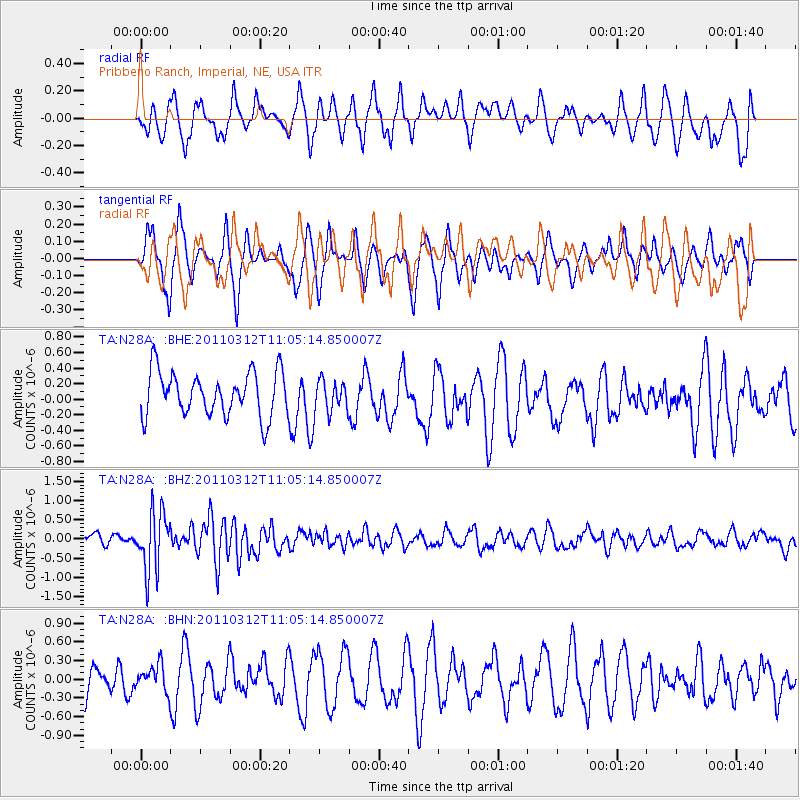
N28A Pribbeno Ranch, Imperial, NE, USA - Earthquake Result Viewer
*The percent match for this event was below the threshold and hence no stack was calculated.
| Earthquake location: |
Near East Coast Of Honshu, Japan |
| Earthquake latitude/longitude: |
39.0/142.3 |
| Earthquake time(UTC): |
2011/03/12 (071) 10:53:30 GMT |
| Earthquake Depth: |
27 km |
| Earthquake Magnitude: |
6.0 MB, 5.4 MS, 5.7 MW, 5.7 MW |
| Earthquake Catalog/Contributor: |
WHDF/NEIC |
|
| Network: |
TA USArray Transportable Network (new EarthScope stations) |
| Station: |
N28A Pribbeno Ranch, Imperial, NE, USA |
| Lat/Lon: |
40.69 N/101.54 W |
| Elevation: |
1009 m |
|
| Distance: |
81.6 deg |
| Az: |
43.617 deg |
| Baz: |
315.059 deg |
| Ray Param: |
$rayparam |
*The percent match for this event was below the threshold and hence was not used in the summary stack. |
|
| Radial Match: |
58.116013 % |
| Radial Bump: |
400 |
| Transverse Match: |
32.00155 % |
| Transverse Bump: |
273 |
| SOD ConfigId: |
356183 |
| Insert Time: |
2011-08-19 19:03:06.607 +0000 |
| GWidth: |
2.5 |
| Max Bumps: |
400 |
| Tol: |
0.001 |
|
Signal To Noise
| Channel | StoN | STA | LTA |
| TA:N28A: :BHZ:20110312T11:05:14.850007Z | 5.838664 | 7.741837E-7 | 1.3259604E-7 |
| TA:N28A: :BHN:20110312T11:05:14.850007Z | 0.5285049 | 2.2329212E-7 | 4.2249775E-7 |
| TA:N28A: :BHE:20110312T11:05:14.850007Z | 0.7197834 | 2.0339027E-7 | 2.8257148E-7 |
| Arrivals |
| Ps | |
| PpPs | |
| PsPs/PpSs | |


