You are here: Home > Network List > AZ - ANZA Regional Network Stations List
> Station RDM AZ.RDM > Earthquake Result Viewer
RDM AZ.RDM - Earthquake Result Viewer
| Earthquake location: |
Kermadec Islands Region |
| Earthquake latitude/longitude: |
-31.2/180.0 |
| Earthquake time(UTC): |
1996/11/05 (310) 09:41:34 GMT |
| Earthquake Depth: |
369 km |
| Earthquake Magnitude: |
5.9 MB, 6.8 UNKNOWN, 6.7 MW |
| Earthquake Catalog/Contributor: |
WHDF/NEIC |
|
| Network: |
AZ ANZA Regional Network |
| Station: |
RDM AZ.RDM |
| Lat/Lon: |
33.63 N/116.85 W |
| Elevation: |
1365 m |
|
| Distance: |
87.8 deg |
| Az: |
48.158 deg |
| Baz: |
229.947 deg |
| Ray Param: |
0.042148624 |
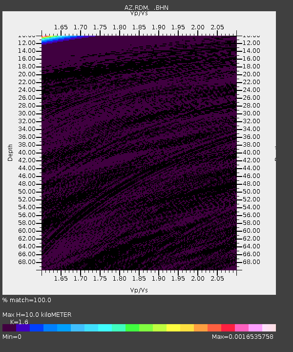
| Estimated Moho Depth: |
10.0 km |
| Estimated Crust Vp/Vs: |
1.60 |
| Assumed Crust Vp: |
6.264 km/s |
| Estimated Crust Vs: |
3.915 km/s |
| Estimated Crust Poisson's Ratio: |
0.18 |
|
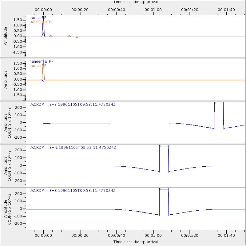
| Radial Match: |
100.0 % |
| Radial Bump: |
2 |
| Transverse Match: |
99.999794 % |
| Transverse Bump: |
2 |
| SOD ConfigId: |
6273 |
| Insert Time: |
2010-02-26 20:30:58.653 +0000 |
| GWidth: |
2.5 |
| Max Bumps: |
400 |
| Tol: |
0.001 |
|
Signal To Noise
| Channel | StoN | STA | LTA |
| AZ:RDM: :BHN:19961105T09:53:11.475024Z | 1.022375 | 0.0017435371 | 0.0017053792 |
| AZ:RDM: :BHE:19961105T09:53:11.475024Z | 1.0258074 | 0.0018114464 | 0.0017658737 |
| AZ:RDM: :BHZ:19961105T09:53:11.475024Z | 1.0221759 | 0.0017885246 | 0.0017497229 |
| Arrivals |
| Ps | 1.0 SECOND |
| PpPs | 4.1 SECOND |
| PsPs/PpSs | 5.0 SECOND |


