You are here: Home > Network List > II - Global Seismograph Network (GSN - IRIS/IDA) Stations List
> Station WRAB Tennant Creek, NT, Australia > Earthquake Result Viewer
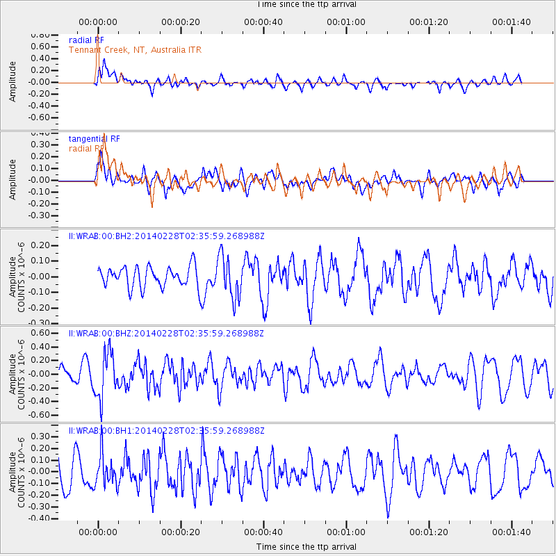
WRAB Tennant Creek, NT, Australia - Earthquake Result Viewer
*The percent match for this event was below the threshold and hence no stack was calculated.
| Earthquake location: |
Philippine Islands Region |
| Earthquake latitude/longitude: |
20.2/120.3 |
| Earthquake time(UTC): |
2014/02/28 (059) 02:28:38 GMT |
| Earthquake Depth: |
16 km |
| Earthquake Magnitude: |
5.0 MW |
| Earthquake Catalog/Contributor: |
ISC/ISC |
|
| Network: |
II Global Seismograph Network (GSN - IRIS/IDA) |
| Station: |
WRAB Tennant Creek, NT, Australia |
| Lat/Lon: |
19.93 S/134.36 E |
| Elevation: |
366 m |
|
| Distance: |
42.2 deg |
| Az: |
160.118 deg |
| Baz: |
340.154 deg |
| Ray Param: |
$rayparam |
*The percent match for this event was below the threshold and hence was not used in the summary stack. |
|
| Radial Match: |
52.607826 % |
| Radial Bump: |
400 |
| Transverse Match: |
58.824795 % |
| Transverse Bump: |
400 |
| SOD ConfigId: |
3390531 |
| Insert Time: |
2019-04-10 11:04:07.566 +0000 |
| GWidth: |
2.5 |
| Max Bumps: |
400 |
| Tol: |
0.001 |
|
Signal To Noise
| Channel | StoN | STA | LTA |
| II:WRAB:00:BHZ:20140228T02:35:59.268988Z | 3.2193437 | 3.3762745E-7 | 1.0487463E-7 |
| II:WRAB:00:BH1:20140228T02:35:59.268988Z | 0.98245853 | 1.362583E-7 | 1.3869114E-7 |
| II:WRAB:00:BH2:20140228T02:35:59.268988Z | 2.0883367 | 1.3743797E-7 | 6.581217E-8 |
| Arrivals |
| Ps | |
| PpPs | |
| PsPs/PpSs | |


