You are here: Home > Network List > AZ - ANZA Regional Network Stations List
> Station RDM AZ.RDM > Earthquake Result Viewer
RDM AZ.RDM - Earthquake Result Viewer

| Earthquake location: |
Solomon Islands |
| Earthquake latitude/longitude: |
-10.8/161.4 |
| Earthquake time(UTC): |
1996/08/02 (215) 12:55:29 GMT |
| Earthquake Depth: |
33 km |
| Earthquake Magnitude: |
6.2 MB, 7.1 MS, 6.9 UNKNOWN, 6.9 MW |
| Earthquake Catalog/Contributor: |
WHDF/NEIC |
|
| Network: |
AZ ANZA Regional Network |
| Station: |
RDM AZ.RDM |
| Lat/Lon: |
33.63 N/116.85 W |
| Elevation: |
1365 m |
|
| Distance: |
89.1 deg |
| Az: |
55.662 deg |
| Baz: |
256.524 deg |
| Ray Param: |
0.042064022 |
| Estimated Moho Depth: |
26.25 km |
| Estimated Crust Vp/Vs: |
1.86 |
| Assumed Crust Vp: |
6.264 km/s |
| Estimated Crust Vs: |
3.377 km/s |
| Estimated Crust Poisson's Ratio: |
0.30 |
|
| Radial Match: |
93.610756 % |
| Radial Bump: |
400 |
| Transverse Match: |
88.663216 % |
| Transverse Bump: |
400 |
| SOD ConfigId: |
6273 |
| Insert Time: |
2010-02-26 20:31:17.342 +0000 |
| GWidth: |
2.5 |
| Max Bumps: |
400 |
| Tol: |
0.001 |
|
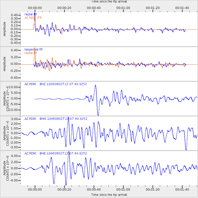
Signal To Noise
| Channel | StoN | STA | LTA |
| AZ:RDM: :BHN:19960802T13:07:49.925Z | 1.1289442 | 3.0201016E-7 | 2.675156E-7 |
| AZ:RDM: :BHE:19960802T13:07:49.925Z | 2.3653147 | 3.8479502E-7 | 1.6268237E-7 |
| AZ:RDM: :BHZ:19960802T13:07:49.925Z | 3.3563058 | 7.7822017E-7 | 2.3186807E-7 |
| Arrivals |
| Ps | 3.7 SECOND |
| PpPs | 12 SECOND |
| PsPs/PpSs | 15 SECOND |


