You are here: Home > Network List > AZ - ANZA Regional Network Stations List
> Station RDM AZ.RDM > Earthquake Result Viewer
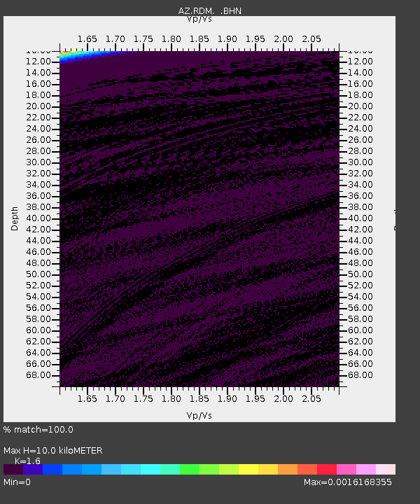
RDM AZ.RDM - Earthquake Result Viewer
| Earthquake location: |
South Of Fiji Islands |
| Earthquake latitude/longitude: |
-25.5/178.3 |
| Earthquake time(UTC): |
1997/08/26 (238) 15:22:09 GMT |
| Earthquake Depth: |
610 km |
| Earthquake Magnitude: |
5.5 MB, 5.7 UNKNOWN |
| Earthquake Catalog/Contributor: |
WHDF/NEIC |
|
| Network: |
AZ ANZA Regional Network |
| Station: |
RDM AZ.RDM |
| Lat/Lon: |
33.63 N/116.85 W |
| Elevation: |
1365 m |
|
| Distance: |
85.1 deg |
| Az: |
49.269 deg |
| Baz: |
235.156 deg |
| Ray Param: |
0.043185342 |
| Estimated Moho Depth: |
10.0 km |
| Estimated Crust Vp/Vs: |
1.60 |
| Assumed Crust Vp: |
6.264 km/s |
| Estimated Crust Vs: |
3.915 km/s |
| Estimated Crust Poisson's Ratio: |
0.18 |
|
| Radial Match: |
100.0 % |
| Radial Bump: |
2 |
| Transverse Match: |
100.0 % |
| Transverse Bump: |
2 |
| SOD ConfigId: |
9875 |
| Insert Time: |
2010-02-26 20:31:32.934 +0000 |
| GWidth: |
2.5 |
| Max Bumps: |
400 |
| Tol: |
0.001 |
|

Signal To Noise
| Channel | StoN | STA | LTA |
| AZ:RDM: :BHN:19970826T15:33:10.875024Z | 0.9189342 | 0.002670908 | 0.0029065283 |
| AZ:RDM: :BHE:19970826T15:33:10.875024Z | 0.918906 | 0.0026707286 | 0.0029064221 |
| AZ:RDM: :BHZ:19970826T15:33:10.875024Z | 0.91892457 | 0.0026708527 | 0.0029064985 |
| Arrivals |
| Ps | 1.0 SECOND |
| PpPs | 4.1 SECOND |
| PsPs/PpSs | 5.0 SECOND |


