You are here: Home > Network List > AK - Alaska Regional Network Stations List
> Station CHI Chirikof Island > Earthquake Result Viewer
CHI Chirikof Island - Earthquake Result Viewer
| Earthquake location: |
Kermadec Islands Region |
| Earthquake latitude/longitude: |
-28.5/-176.4 |
| Earthquake time(UTC): |
2014/02/28 (059) 19:41:17 GMT |
| Earthquake Depth: |
29 km |
| Earthquake Magnitude: |
5.0 MW |
| Earthquake Catalog/Contributor: |
ISC/ISC |
|
| Network: |
AK Alaska Regional Network |
| Station: |
CHI Chirikof Island |
| Lat/Lon: |
55.82 N/155.62 W |
| Elevation: |
234 m |
|
| Distance: |
85.9 deg |
| Az: |
11.565 deg |
| Baz: |
198.212 deg |
| Ray Param: |
0.044410594 |
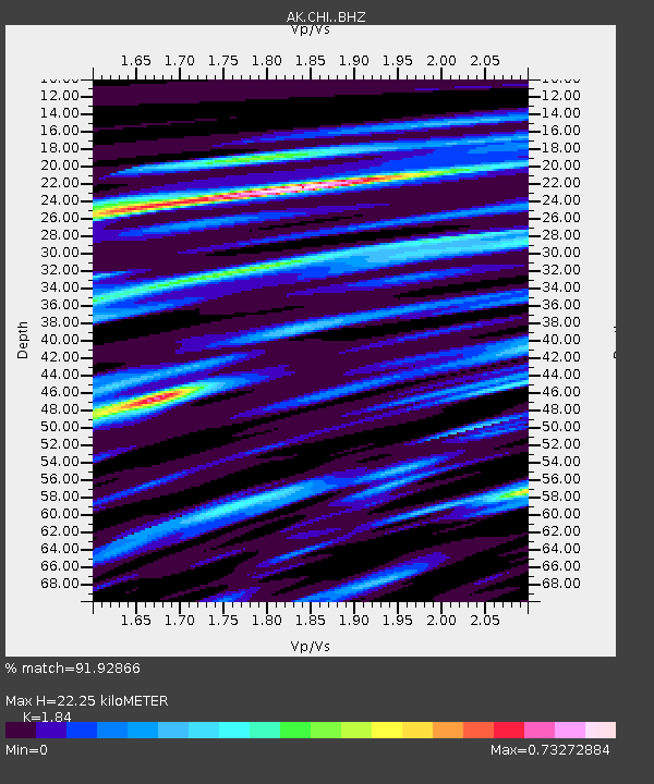
| Estimated Moho Depth: |
22.25 km |
| Estimated Crust Vp/Vs: |
1.84 |
| Assumed Crust Vp: |
3.999 km/s |
| Estimated Crust Vs: |
2.173 km/s |
| Estimated Crust Poisson's Ratio: |
0.29 |
|
| Radial Match: |
91.92866 % |
| Radial Bump: |
272 |
| Transverse Match: |
49.48446 % |
| Transverse Bump: |
400 |
| SOD ConfigId: |
3390531 |
| Insert Time: |
2019-04-10 11:06:42.550 +0000 |
| GWidth: |
2.5 |
| Max Bumps: |
400 |
| Tol: |
0.001 |
|

Signal To Noise
| Channel | StoN | STA | LTA |
| AK:CHI: :BHZ:20140228T19:53:22.847998Z | 0.7771806 | 7.8581263E-7 | 1.0111069E-6 |
| AK:CHI: :BHN:20140228T19:53:22.847998Z | 0.5114816 | 9.434045E-7 | 1.8444545E-6 |
| AK:CHI: :BHE:20140228T19:53:22.847998Z | 0.70009863 | 1.4876608E-6 | 2.1249305E-6 |
| Arrivals |
| Ps | 4.7 SECOND |
| PpPs | 16 SECOND |
| PsPs/PpSs | 20 SECOND |


