You are here: Home > Network List > US - United States National Seismic Network Stations List
> Station TPNV Topopah Spring, Nevada, USA > Earthquake Result Viewer
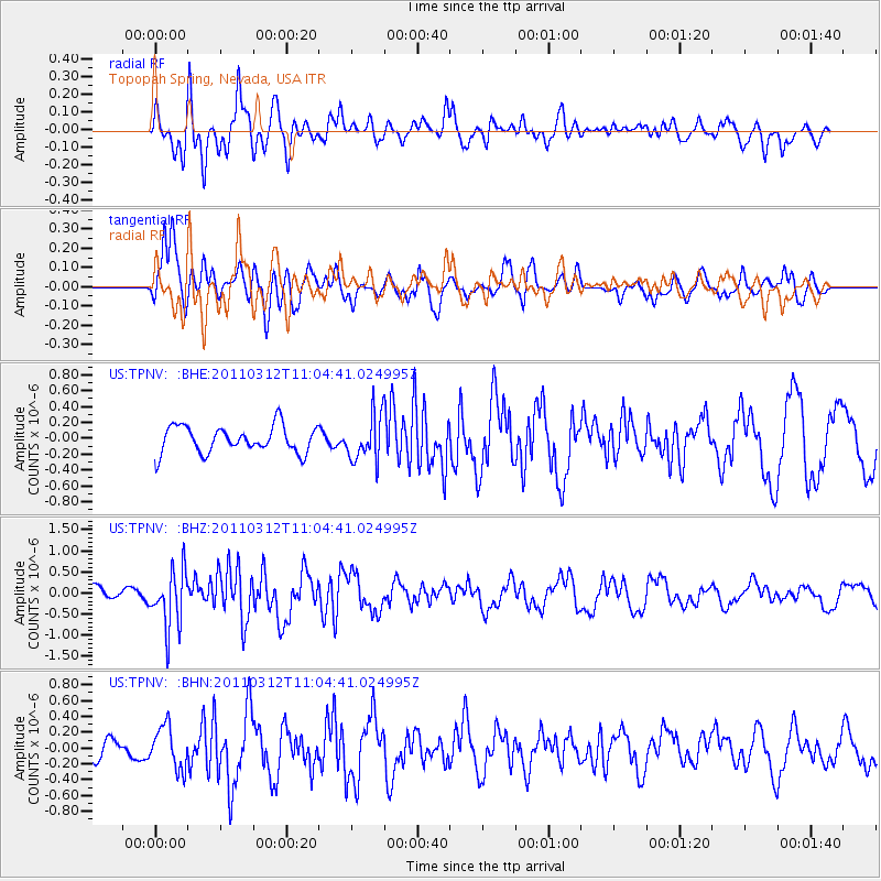
TPNV Topopah Spring, Nevada, USA - Earthquake Result Viewer
*The percent match for this event was below the threshold and hence no stack was calculated.
| Earthquake location: |
Near East Coast Of Honshu, Japan |
| Earthquake latitude/longitude: |
39.0/142.3 |
| Earthquake time(UTC): |
2011/03/12 (071) 10:53:30 GMT |
| Earthquake Depth: |
27 km |
| Earthquake Magnitude: |
6.0 MB, 5.4 MS, 5.7 MW, 5.7 MW |
| Earthquake Catalog/Contributor: |
WHDF/NEIC |
|
| Network: |
US United States National Seismic Network |
| Station: |
TPNV Topopah Spring, Nevada, USA |
| Lat/Lon: |
36.95 N/116.25 W |
| Elevation: |
1600 m |
|
| Distance: |
75.4 deg |
| Az: |
54.21 deg |
| Baz: |
307.959 deg |
| Ray Param: |
$rayparam |
*The percent match for this event was below the threshold and hence was not used in the summary stack. |
|
| Radial Match: |
67.19954 % |
| Radial Bump: |
400 |
| Transverse Match: |
71.42191 % |
| Transverse Bump: |
400 |
| SOD ConfigId: |
356183 |
| Insert Time: |
2011-08-19 20:32:49.903 +0000 |
| GWidth: |
2.5 |
| Max Bumps: |
400 |
| Tol: |
0.001 |
|
Signal To Noise
| Channel | StoN | STA | LTA |
| US:TPNV: :BHZ:20110312T11:04:41.024995Z | 3.3840542 | 6.801896E-7 | 2.0099843E-7 |
| US:TPNV: :BHN:20110312T11:04:41.024995Z | 1.5512154 | 2.6651395E-7 | 1.7180976E-7 |
| US:TPNV: :BHE:20110312T11:04:41.024995Z | 1.7189015 | 2.8896577E-7 | 1.6811072E-7 |
| Arrivals |
| Ps | |
| PpPs | |
| PsPs/PpSs | |


