You are here: Home > Network List > UW - Pacific Northwest Regional Seismic Network Stations List
> Station LCCR Mulino, OR, USA > Earthquake Result Viewer
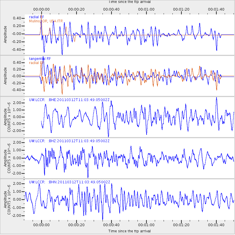
LCCR Mulino, OR, USA - Earthquake Result Viewer
*The percent match for this event was below the threshold and hence no stack was calculated.
| Earthquake location: |
Near East Coast Of Honshu, Japan |
| Earthquake latitude/longitude: |
39.0/142.3 |
| Earthquake time(UTC): |
2011/03/12 (071) 10:53:30 GMT |
| Earthquake Depth: |
27 km |
| Earthquake Magnitude: |
6.0 MB, 5.4 MS, 5.7 MW, 5.7 MW |
| Earthquake Catalog/Contributor: |
WHDF/NEIC |
|
| Network: |
UW Pacific Northwest Regional Seismic Network |
| Station: |
LCCR Mulino, OR, USA |
| Lat/Lon: |
45.21 N/122.48 W |
| Elevation: |
273 m |
|
| Distance: |
66.8 deg |
| Az: |
49.974 deg |
| Baz: |
302.494 deg |
| Ray Param: |
$rayparam |
*The percent match for this event was below the threshold and hence was not used in the summary stack. |
|
| Radial Match: |
40.92675 % |
| Radial Bump: |
400 |
| Transverse Match: |
49.683952 % |
| Transverse Bump: |
400 |
| SOD ConfigId: |
356183 |
| Insert Time: |
2011-08-19 20:47:09.076 +0000 |
| GWidth: |
2.5 |
| Max Bumps: |
400 |
| Tol: |
0.001 |
|
Signal To Noise
| Channel | StoN | STA | LTA |
| UW:LCCR: :BHZ:20110312T11:03:49.05002Z | 1.8646457 | 7.779785E-7 | 4.1722592E-7 |
| UW:LCCR: :BHN:20110312T11:03:49.05002Z | 1.2910813 | 8.348059E-7 | 6.4659434E-7 |
| UW:LCCR: :BHE:20110312T11:03:49.05002Z | 1.3095962 | 1.1512304E-6 | 8.7907284E-7 |
| Arrivals |
| Ps | |
| PpPs | |
| PsPs/PpSs | |


