You are here: Home > Network List > TA - USArray Transportable Network (new EarthScope stations) Stations List
> Station I30A Oacoma, SD, USA > Earthquake Result Viewer
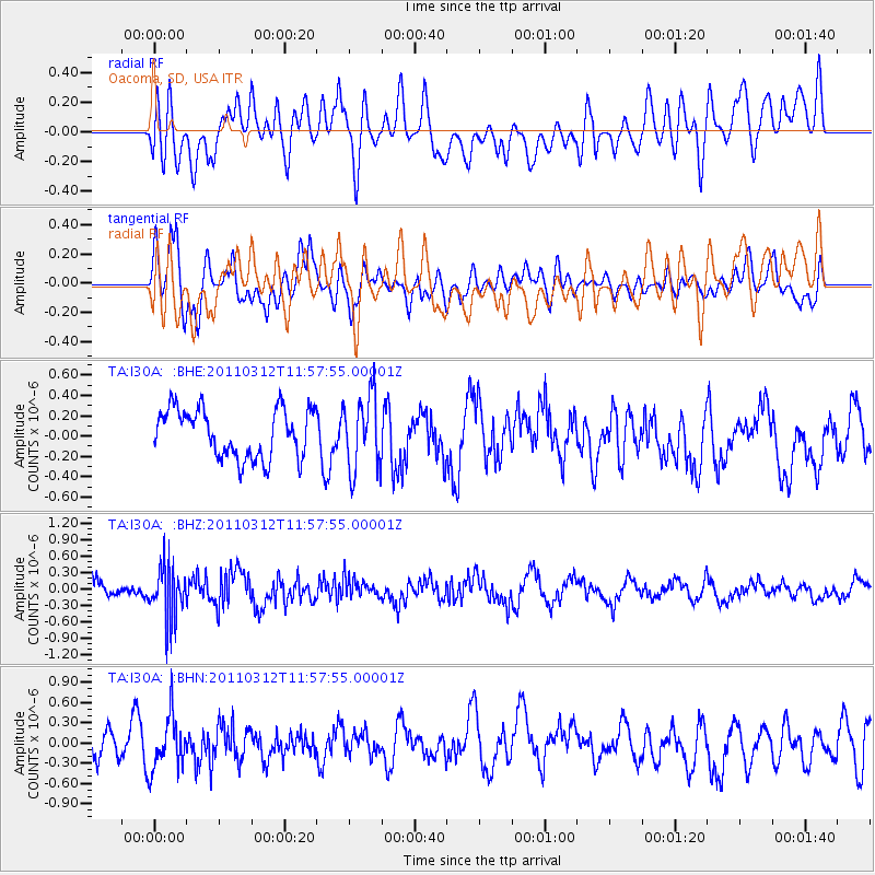
I30A Oacoma, SD, USA - Earthquake Result Viewer
*The percent match for this event was below the threshold and hence no stack was calculated.
| Earthquake location: |
Near East Coast Of Honshu, Japan |
| Earthquake latitude/longitude: |
35.7/141.7 |
| Earthquake time(UTC): |
2011/03/12 (071) 11:45:59 GMT |
| Earthquake Depth: |
10 km |
| Earthquake Magnitude: |
5.6 MB |
| Earthquake Catalog/Contributor: |
WHDF/NEIC |
|
| Network: |
TA USArray Transportable Network (new EarthScope stations) |
| Station: |
I30A Oacoma, SD, USA |
| Lat/Lon: |
43.91 N/99.43 W |
| Elevation: |
549 m |
|
| Distance: |
83.2 deg |
| Az: |
39.582 deg |
| Baz: |
314.173 deg |
| Ray Param: |
$rayparam |
*The percent match for this event was below the threshold and hence was not used in the summary stack. |
|
| Radial Match: |
47.373524 % |
| Radial Bump: |
400 |
| Transverse Match: |
59.491734 % |
| Transverse Bump: |
400 |
| SOD ConfigId: |
356183 |
| Insert Time: |
2011-08-19 21:39:09.041 +0000 |
| GWidth: |
2.5 |
| Max Bumps: |
400 |
| Tol: |
0.001 |
|
Signal To Noise
| Channel | StoN | STA | LTA |
| TA:I30A: :BHZ:20110312T11:57:55.00001Z | 2.3843431 | 4.844127E-7 | 2.0316399E-7 |
| TA:I30A: :BHN:20110312T11:57:55.00001Z | 1.0944543 | 3.974293E-7 | 3.631301E-7 |
| TA:I30A: :BHE:20110312T11:57:55.00001Z | 1.5261936 | 3.6394147E-7 | 2.3846349E-7 |
| Arrivals |
| Ps | |
| PpPs | |
| PsPs/PpSs | |


