You are here: Home > Network List > TA - USArray Transportable Network (new EarthScope stations) Stations List
> Station Z41A Richland Creek Farm, El Dorado, AR, USA > Earthquake Result Viewer
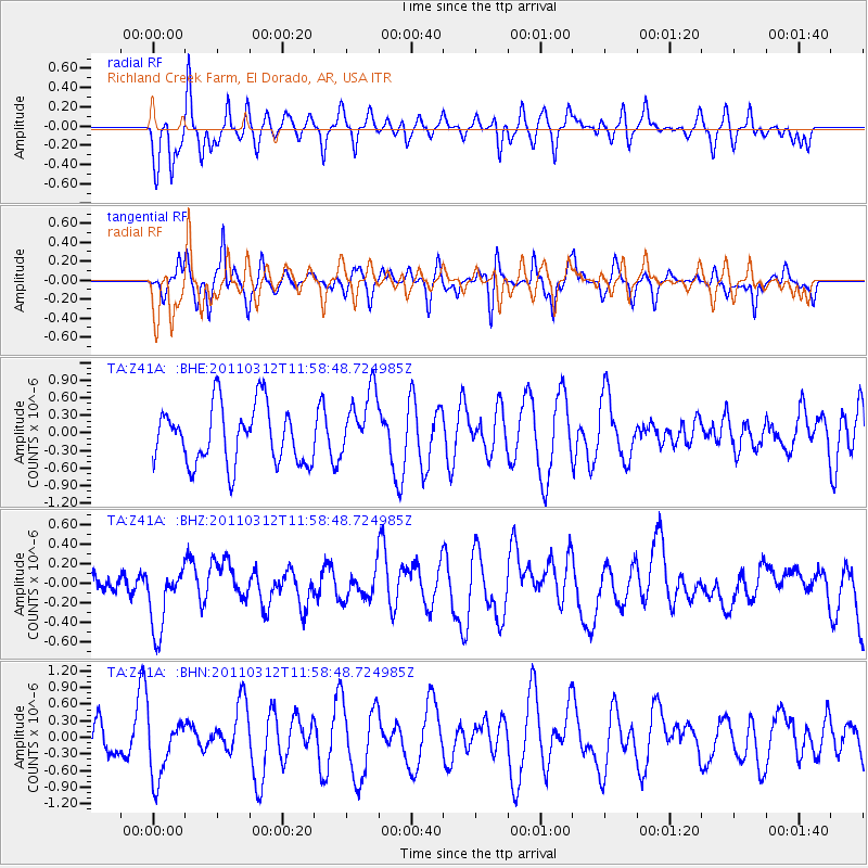
Z41A Richland Creek Farm, El Dorado, AR, USA - Earthquake Result Viewer
*The percent match for this event was below the threshold and hence no stack was calculated.
| Earthquake location: |
Near East Coast Of Honshu, Japan |
| Earthquake latitude/longitude: |
35.7/141.7 |
| Earthquake time(UTC): |
2011/03/12 (071) 11:45:59 GMT |
| Earthquake Depth: |
10 km |
| Earthquake Magnitude: |
5.6 MB |
| Earthquake Catalog/Contributor: |
WHDF/NEIC |
|
| Network: |
TA USArray Transportable Network (new EarthScope stations) |
| Station: |
Z41A Richland Creek Farm, El Dorado, AR, USA |
| Lat/Lon: |
33.26 N/92.80 W |
| Elevation: |
62 m |
|
| Distance: |
94.5 deg |
| Az: |
43.167 deg |
| Baz: |
318.379 deg |
| Ray Param: |
$rayparam |
*The percent match for this event was below the threshold and hence was not used in the summary stack. |
|
| Radial Match: |
55.495205 % |
| Radial Bump: |
314 |
| Transverse Match: |
42.202374 % |
| Transverse Bump: |
270 |
| SOD ConfigId: |
356183 |
| Insert Time: |
2011-08-19 21:54:54.982 +0000 |
| GWidth: |
2.5 |
| Max Bumps: |
400 |
| Tol: |
0.001 |
|
Signal To Noise
| Channel | StoN | STA | LTA |
| TA:Z41A: :BHZ:20110312T11:58:48.724985Z | 2.0051193 | 3.5931907E-7 | 1.7920085E-7 |
| TA:Z41A: :BHN:20110312T11:58:48.724985Z | 1.1251307 | 5.595645E-7 | 4.973329E-7 |
| TA:Z41A: :BHE:20110312T11:58:48.724985Z | 1.1767402 | 5.7821336E-7 | 4.913687E-7 |
| Arrivals |
| Ps | |
| PpPs | |
| PsPs/PpSs | |


