You are here: Home > Network List > US - United States National Seismic Network Stations List
> Station TPNV Topopah Spring, Nevada, USA > Earthquake Result Viewer
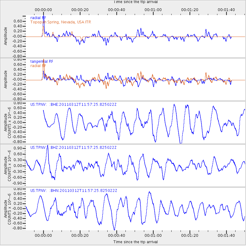
TPNV Topopah Spring, Nevada, USA - Earthquake Result Viewer
*The percent match for this event was below the threshold and hence no stack was calculated.
| Earthquake location: |
Near East Coast Of Honshu, Japan |
| Earthquake latitude/longitude: |
35.7/141.7 |
| Earthquake time(UTC): |
2011/03/12 (071) 11:45:59 GMT |
| Earthquake Depth: |
10 km |
| Earthquake Magnitude: |
5.6 MB |
| Earthquake Catalog/Contributor: |
WHDF/NEIC |
|
| Network: |
US United States National Seismic Network |
| Station: |
TPNV Topopah Spring, Nevada, USA |
| Lat/Lon: |
36.95 N/116.25 W |
| Elevation: |
1600 m |
|
| Distance: |
77.8 deg |
| Az: |
53.282 deg |
| Baz: |
305.513 deg |
| Ray Param: |
$rayparam |
*The percent match for this event was below the threshold and hence was not used in the summary stack. |
|
| Radial Match: |
67.715195 % |
| Radial Bump: |
400 |
| Transverse Match: |
44.58773 % |
| Transverse Bump: |
400 |
| SOD ConfigId: |
356183 |
| Insert Time: |
2011-08-19 21:56:08.297 +0000 |
| GWidth: |
2.5 |
| Max Bumps: |
400 |
| Tol: |
0.001 |
|
Signal To Noise
| Channel | StoN | STA | LTA |
| US:TPNV: :BHZ:20110312T11:57:25.825022Z | 2.007289 | 4.9265043E-7 | 2.4543075E-7 |
| US:TPNV: :BHN:20110312T11:57:25.825022Z | 0.96684074 | 2.8711432E-7 | 2.9696133E-7 |
| US:TPNV: :BHE:20110312T11:57:25.825022Z | 0.45916122 | 1.4931676E-7 | 3.2519463E-7 |
| Arrivals |
| Ps | |
| PpPs | |
| PsPs/PpSs | |


