You are here: Home > Network List > UW - Pacific Northwest Regional Seismic Network Stations List
> Station YACT Amboy, WA, USA > Earthquake Result Viewer
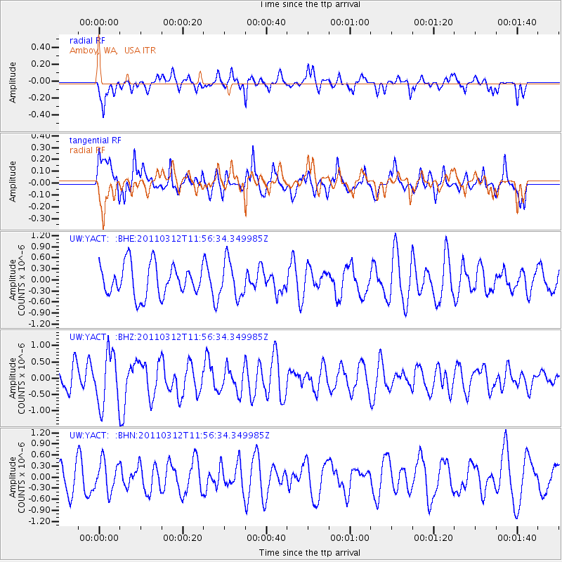
YACT Amboy, WA, USA - Earthquake Result Viewer
*The percent match for this event was below the threshold and hence no stack was calculated.
| Earthquake location: |
Near East Coast Of Honshu, Japan |
| Earthquake latitude/longitude: |
35.7/141.7 |
| Earthquake time(UTC): |
2011/03/12 (071) 11:45:59 GMT |
| Earthquake Depth: |
10 km |
| Earthquake Magnitude: |
5.6 MB |
| Earthquake Catalog/Contributor: |
WHDF/NEIC |
|
| Network: |
UW Pacific Northwest Regional Seismic Network |
| Station: |
YACT Amboy, WA, USA |
| Lat/Lon: |
45.93 N/122.42 W |
| Elevation: |
211 m |
|
| Distance: |
69.0 deg |
| Az: |
48.034 deg |
| Baz: |
299.925 deg |
| Ray Param: |
$rayparam |
*The percent match for this event was below the threshold and hence was not used in the summary stack. |
|
| Radial Match: |
60.51681 % |
| Radial Bump: |
400 |
| Transverse Match: |
61.22866 % |
| Transverse Bump: |
400 |
| SOD ConfigId: |
356183 |
| Insert Time: |
2011-08-19 22:01:47.387 +0000 |
| GWidth: |
2.5 |
| Max Bumps: |
400 |
| Tol: |
0.001 |
|
Signal To Noise
| Channel | StoN | STA | LTA |
| UW:YACT: :BHZ:20110312T11:56:34.349985Z | 2.1855698 | 8.342664E-7 | 3.8171578E-7 |
| UW:YACT: :BHN:20110312T11:56:34.349985Z | 0.9984388 | 4.150087E-7 | 4.1565764E-7 |
| UW:YACT: :BHE:20110312T11:56:34.349985Z | 1.1627452 | 4.942816E-7 | 4.2509876E-7 |
| Arrivals |
| Ps | |
| PpPs | |
| PsPs/PpSs | |


