You are here: Home > Network List > TA - USArray Transportable Network (new EarthScope stations) Stations List
> Station TUL1 Leonard, OK, USA > Earthquake Result Viewer
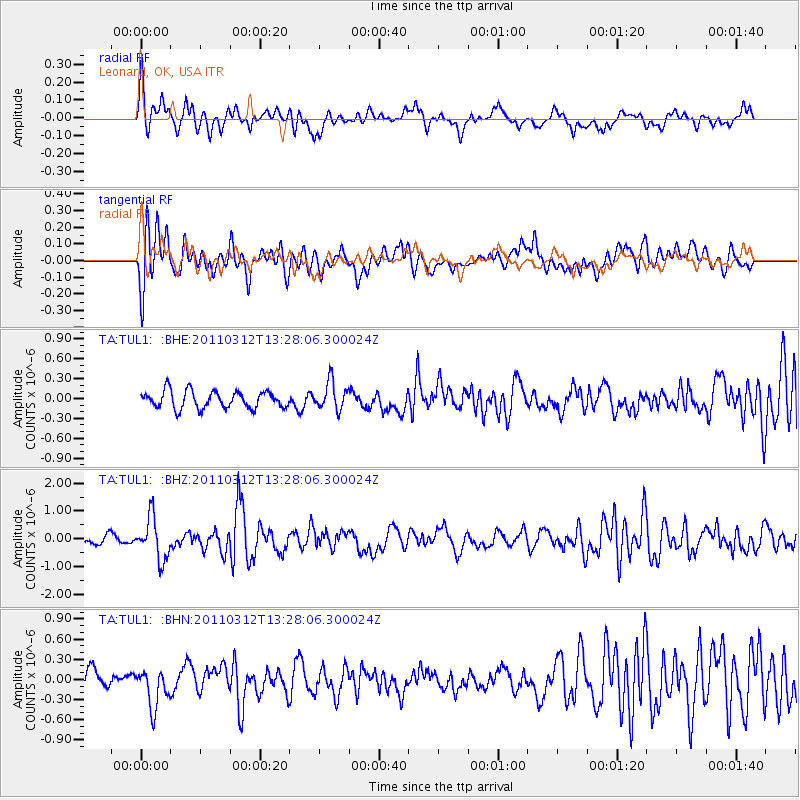
TUL1 Leonard, OK, USA - Earthquake Result Viewer
*The percent match for this event was below the threshold and hence no stack was calculated.
| Earthquake location: |
Near East Coast Of Honshu, Japan |
| Earthquake latitude/longitude: |
37.2/141.2 |
| Earthquake time(UTC): |
2011/03/12 (071) 13:15:41 GMT |
| Earthquake Depth: |
38 km |
| Earthquake Magnitude: |
6.1 MB, 5.9 MS, 6.2 MW, 6.1 MW |
| Earthquake Catalog/Contributor: |
WHDF/NEIC |
|
| Network: |
TA USArray Transportable Network (new EarthScope stations) |
| Station: |
TUL1 Leonard, OK, USA |
| Lat/Lon: |
35.91 N/95.79 W |
| Elevation: |
256 m |
|
| Distance: |
90.1 deg |
| Az: |
42.879 deg |
| Baz: |
318.021 deg |
| Ray Param: |
$rayparam |
*The percent match for this event was below the threshold and hence was not used in the summary stack. |
|
| Radial Match: |
70.52627 % |
| Radial Bump: |
400 |
| Transverse Match: |
67.3931 % |
| Transverse Bump: |
400 |
| SOD ConfigId: |
356183 |
| Insert Time: |
2011-08-19 23:32:54.379 +0000 |
| GWidth: |
2.5 |
| Max Bumps: |
400 |
| Tol: |
0.001 |
|
Signal To Noise
| Channel | StoN | STA | LTA |
| TA:TUL1: :BHZ:20110312T13:28:06.300024Z | 3.26977 | 7.520414E-7 | 2.2999826E-7 |
| TA:TUL1: :BHN:20110312T13:28:06.300024Z | 1.8482808 | 2.8431054E-7 | 1.5382433E-7 |
| TA:TUL1: :BHE:20110312T13:28:06.300024Z | 1.6226788 | 2.1033227E-7 | 1.296204E-7 |
| Arrivals |
| Ps | |
| PpPs | |
| PsPs/PpSs | |


