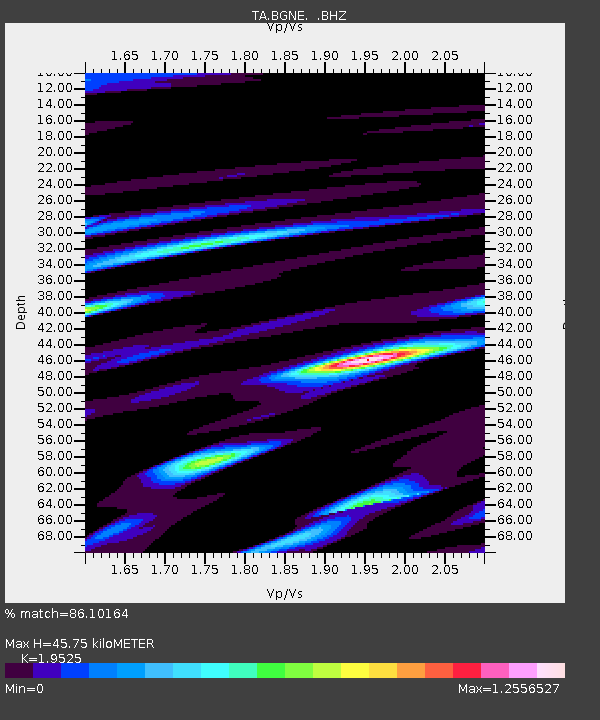
BGNE Belgrade, NE, USA - Earthquake Result Viewer
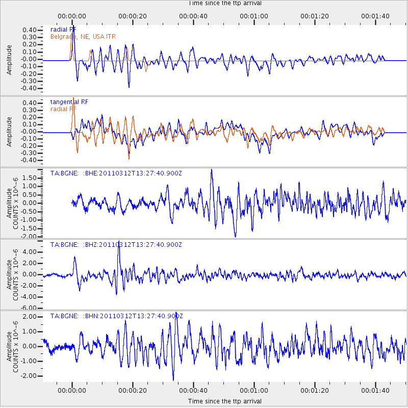
Earthquake location: Near East Coast Of Honshu, Japan
Earthquake latitude/longitude: 37.2/141.2
Earthquake time(UTC): 2011/03/12 (071) 13:15:41 GMT
Earthquake Depth: 38 km
Earthquake Magnitude: 6.1 MB, 5.9 MS, 6.2 MW, 6.1 MW
Earthquake Catalog/Contributor: WHDF/NEIC
Network: TA USArray Transportable Network (new EarthScope stations)
Station: BGNE Belgrade, NE, USA
Lat/Lon: 41.41 N/98.15 W
Elevation: 573 m
Distance: 84.8 deg
Az: 40.507 deg
Baz: 316.446 deg
Ray Param: 0.045173097
Estimated Moho Depth: 45.75 km
Estimated Crust Vp/Vs: 1.95
Assumed Crust Vp: 6.53 km/s
Estimated Crust Vs: 3.345 km/s
Estimated Crust Poisson's Ratio: 0.32
Radial Match: 86.10164 %
Radial Bump: 400
Transverse Match: 73.31138 %
Transverse Bump: 400
SOD ConfigId: 356183
Insert Time: 2011-08-19 23:33:21.099 +0000
GWidth: 2.5
Max Bumps: 400
Tol: 0.001

Signal To Noise

ChannelStoNSTALTA
TA:BGNE: :BHZ:20110312T13:27:40.900Z8.4989851.3945568E-61.640851E-7
TA:BGNE: :BHN:20110312T13:27:40.900Z1.79004165.025488E-72.80747E-7
TA:BGNE: :BHE:20110312T13:27:40.900Z2.135725.8939366E-72.759695E-7
Arrivals
Ps6.8 SECOND
PpPs20 SECOND
PsPs/PpSs27 SECOND