You are here: Home > Network List > TA - USArray Transportable Network (new EarthScope stations) Stations List
> Station S29A Ulysses, KS, USA > Earthquake Result Viewer
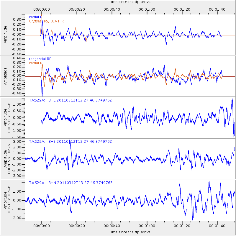
S29A Ulysses, KS, USA - Earthquake Result Viewer
*The percent match for this event was below the threshold and hence no stack was calculated.
| Earthquake location: |
Near East Coast Of Honshu, Japan |
| Earthquake latitude/longitude: |
37.2/141.2 |
| Earthquake time(UTC): |
2011/03/12 (071) 13:15:41 GMT |
| Earthquake Depth: |
38 km |
| Earthquake Magnitude: |
6.1 MB, 5.9 MS, 6.2 MW, 6.1 MW |
| Earthquake Catalog/Contributor: |
WHDF/NEIC |
|
| Network: |
TA USArray Transportable Network (new EarthScope stations) |
| Station: |
S29A Ulysses, KS, USA |
| Lat/Lon: |
37.62 N/101.12 W |
| Elevation: |
931 m |
|
| Distance: |
85.9 deg |
| Az: |
44.806 deg |
| Baz: |
314.913 deg |
| Ray Param: |
$rayparam |
*The percent match for this event was below the threshold and hence was not used in the summary stack. |
|
| Radial Match: |
72.11719 % |
| Radial Bump: |
400 |
| Transverse Match: |
73.27314 % |
| Transverse Bump: |
393 |
| SOD ConfigId: |
356183 |
| Insert Time: |
2011-08-19 23:35:53.455 +0000 |
| GWidth: |
2.5 |
| Max Bumps: |
400 |
| Tol: |
0.001 |
|
Signal To Noise
| Channel | StoN | STA | LTA |
| TA:S29A: :BHZ:20110312T13:27:46.374976Z | 6.387555 | 9.781901E-7 | 1.5314E-7 |
| TA:S29A: :BHN:20110312T13:27:46.374976Z | 2.0425255 | 3.5648026E-7 | 1.7452916E-7 |
| TA:S29A: :BHE:20110312T13:27:46.374976Z | 1.5335304 | 2.9166807E-7 | 1.9019387E-7 |
| Arrivals |
| Ps | |
| PpPs | |
| PsPs/PpSs | |


