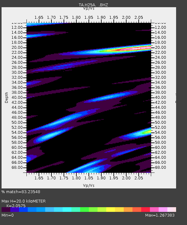
H25A Fruitdale, SD, USA - Earthquake Result Viewer
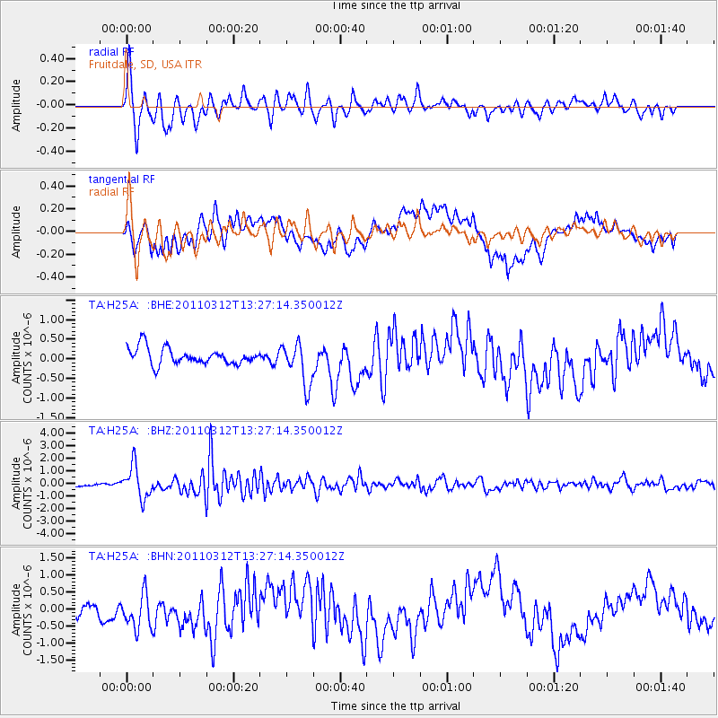
Earthquake location: Near East Coast Of Honshu, Japan
Earthquake latitude/longitude: 37.2/141.2
Earthquake time(UTC): 2011/03/12 (071) 13:15:41 GMT
Earthquake Depth: 38 km
Earthquake Magnitude: 6.1 MB, 5.9 MS, 6.2 MW, 6.1 MW
Earthquake Catalog/Contributor: WHDF/NEIC
Network: TA USArray Transportable Network (new EarthScope stations)
Station: H25A Fruitdale, SD, USA
Lat/Lon: 44.62 N/103.60 W
Elevation: 942 m
Distance: 79.7 deg
Az: 41.035 deg
Baz: 312.811 deg
Ray Param: 0.048727557
Estimated Moho Depth: 20.0 km
Estimated Crust Vp/Vs: 2.06
Assumed Crust Vp: 6.242 km/s
Estimated Crust Vs: 3.034 km/s
Estimated Crust Poisson's Ratio: 0.35
Radial Match: 83.23548 %
Radial Bump: 338
Transverse Match: 47.13553 %
Transverse Bump: 400
SOD ConfigId: 356183
Insert Time: 2011-08-19 23:47:46.454 +0000
GWidth: 2.5
Max Bumps: 400
Tol: 0.001

Signal To Noise

ChannelStoNSTALTA
TA:H25A: :BHZ:20110312T13:27:14.350012Z12.7102291.304554E-61.0263812E-7
TA:H25A: :BHN:20110312T13:27:14.350012Z1.92378415.3584466E-72.7853682E-7
TA:H25A: :BHE:20110312T13:27:14.350012Z2.63203885.5032467E-72.0908685E-7
Arrivals
Ps3.5 SECOND
PpPs9.6 SECOND
PsPs/PpSs13 SECOND