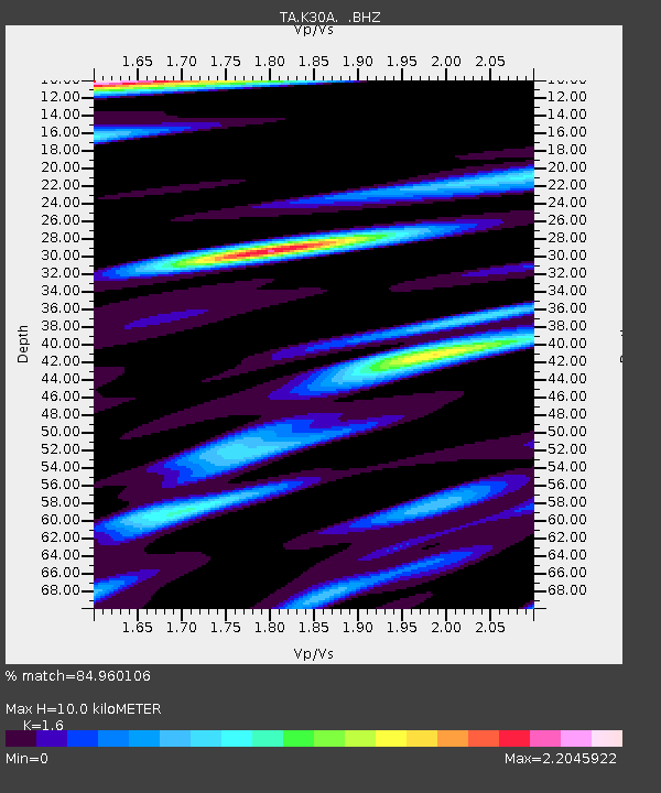
K30A Basset, NE, USA - Earthquake Result Viewer
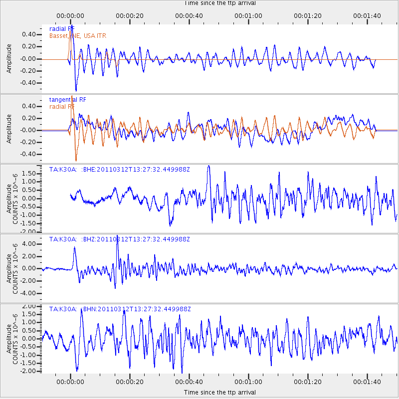
Earthquake location: Near East Coast Of Honshu, Japan
Earthquake latitude/longitude: 37.2/141.2
Earthquake time(UTC): 2011/03/12 (071) 13:15:41 GMT
Earthquake Depth: 38 km
Earthquake Magnitude: 6.1 MB, 5.9 MS, 6.2 MW, 6.1 MW
Earthquake Catalog/Contributor: WHDF/NEIC
Network: TA USArray Transportable Network (new EarthScope stations)
Station: K30A Basset, NE, USA
Lat/Lon: 42.67 N/99.61 W
Elevation: 712 m
Distance: 83.1 deg
Az: 40.41 deg
Baz: 315.459 deg
Ray Param: 0.046354465
Estimated Moho Depth: 10.0 km
Estimated Crust Vp/Vs: 1.60
Assumed Crust Vp: 6.53 km/s
Estimated Crust Vs: 4.082 km/s
Estimated Crust Poisson's Ratio: 0.18
Radial Match: 84.960106 %
Radial Bump: 400
Transverse Match: 71.654884 %
Transverse Bump: 400
SOD ConfigId: 356183
Insert Time: 2011-08-19 23:57:15.142 +0000
GWidth: 2.5
Max Bumps: 400
Tol: 0.001

Signal To Noise

ChannelStoNSTALTA
TA:K30A: :BHZ:20110312T13:27:32.449988Z10.1889181.3740018E-61.3485258E-7
TA:K30A: :BHN:20110312T13:27:32.449988Z3.4396929.929172E-72.8866455E-7
TA:K30A: :BHE:20110312T13:27:32.449988Z3.20666988.6631053E-72.7015895E-7
Arrivals
Ps0.9 SECOND
PpPs3.9 SECOND
PsPs/PpSs4.8 SECOND