You are here: Home > Network List > TA - USArray Transportable Network (new EarthScope stations) Stations List
> Station U33A Lingo Farm, Meno, OK, USA > Earthquake Result Viewer
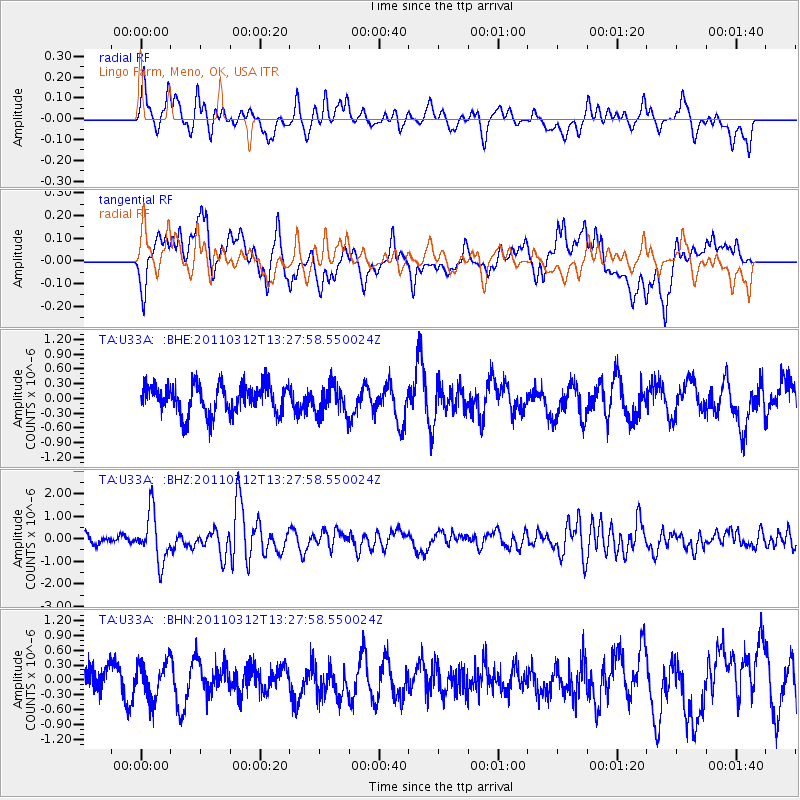
U33A Lingo Farm, Meno, OK, USA - Earthquake Result Viewer
*The percent match for this event was below the threshold and hence no stack was calculated.
| Earthquake location: |
Near East Coast Of Honshu, Japan |
| Earthquake latitude/longitude: |
37.2/141.2 |
| Earthquake time(UTC): |
2011/03/12 (071) 13:15:41 GMT |
| Earthquake Depth: |
38 km |
| Earthquake Magnitude: |
6.1 MB, 5.9 MS, 6.2 MW, 6.1 MW |
| Earthquake Catalog/Contributor: |
WHDF/NEIC |
|
| Network: |
TA USArray Transportable Network (new EarthScope stations) |
| Station: |
U33A Lingo Farm, Meno, OK, USA |
| Lat/Lon: |
36.43 N/98.11 W |
| Elevation: |
393 m |
|
| Distance: |
88.4 deg |
| Az: |
43.908 deg |
| Baz: |
316.67 deg |
| Ray Param: |
$rayparam |
*The percent match for this event was below the threshold and hence was not used in the summary stack. |
|
| Radial Match: |
58.350628 % |
| Radial Bump: |
400 |
| Transverse Match: |
64.050735 % |
| Transverse Bump: |
400 |
| SOD ConfigId: |
356183 |
| Insert Time: |
2011-08-20 00:01:24.767 +0000 |
| GWidth: |
2.5 |
| Max Bumps: |
400 |
| Tol: |
0.001 |
|
Signal To Noise
| Channel | StoN | STA | LTA |
| TA:U33A: :BHZ:20110312T13:27:58.550024Z | 4.301561 | 1.0769999E-6 | 2.503742E-7 |
| TA:U33A: :BHN:20110312T13:27:58.550024Z | 1.2931998 | 3.688156E-7 | 2.8519614E-7 |
| TA:U33A: :BHE:20110312T13:27:58.550024Z | 1.0271488 | 2.984604E-7 | 2.9057173E-7 |
| Arrivals |
| Ps | |
| PpPs | |
| PsPs/PpSs | |


