You are here: Home > Network List > AZ - ANZA Regional Network Stations List
> Station RDM AZ.RDM > Earthquake Result Viewer
RDM AZ.RDM - Earthquake Result Viewer
| Earthquake location: |
South Of Fiji Islands |
| Earthquake latitude/longitude: |
-26.4/178.2 |
| Earthquake time(UTC): |
1999/04/09 (099) 12:16:01 GMT |
| Earthquake Depth: |
621 km |
| Earthquake Magnitude: |
5.5 MB, 6.2 MW, 6.1 MW |
| Earthquake Catalog/Contributor: |
WHDF/NEIC |
|
| Network: |
AZ ANZA Regional Network |
| Station: |
RDM AZ.RDM |
| Lat/Lon: |
33.63 N/116.85 W |
| Elevation: |
1365 m |
|
| Distance: |
85.8 deg |
| Az: |
49.272 deg |
| Baz: |
234.582 deg |
| Ray Param: |
0.04270239 |
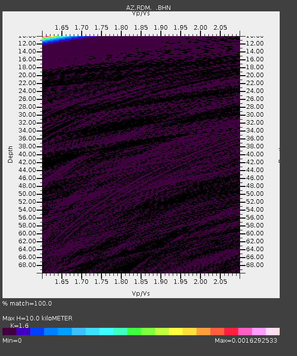
| Estimated Moho Depth: |
10.0 km |
| Estimated Crust Vp/Vs: |
1.60 |
| Assumed Crust Vp: |
6.264 km/s |
| Estimated Crust Vs: |
3.915 km/s |
| Estimated Crust Poisson's Ratio: |
0.18 |
|
| Radial Match: |
100.0 % |
| Radial Bump: |
2 |
| Transverse Match: |
100.0 % |
| Transverse Bump: |
2 |
| SOD ConfigId: |
32974 |
| Insert Time: |
2010-02-26 20:32:31.156 +0000 |
| GWidth: |
2.5 |
| Max Bumps: |
400 |
| Tol: |
0.001 |
|
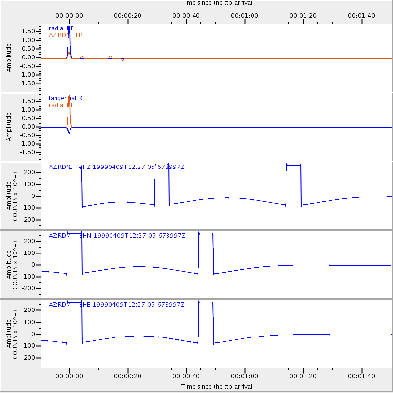
Signal To Noise
| Channel | StoN | STA | LTA |
| AZ:RDM: :BHN:19990409T12:27:05.673997Z | 2.2259057 | 0.25445193 | 0.1143139 |
| AZ:RDM: :BHE:19990409T12:27:05.673997Z | 2.2259002 | 0.25446108 | 0.11431828 |
| AZ:RDM: :BHZ:19990409T12:27:05.673997Z | 2.225902 | 0.25446177 | 0.11431849 |
| Arrivals |
| Ps | 1.0 SECOND |
| PpPs | 4.1 SECOND |
| PsPs/PpSs | 5.0 SECOND |


