You are here: Home > Network List > TA - USArray Transportable Network (new EarthScope stations) Stations List
> Station Z36A Blue Ridge, TX, USA > Earthquake Result Viewer
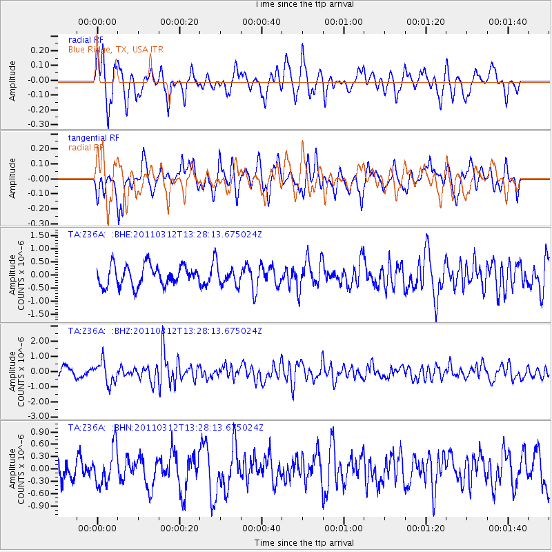
Z36A Blue Ridge, TX, USA - Earthquake Result Viewer
*The percent match for this event was below the threshold and hence no stack was calculated.
| Earthquake location: |
Near East Coast Of Honshu, Japan |
| Earthquake latitude/longitude: |
37.2/141.2 |
| Earthquake time(UTC): |
2011/03/12 (071) 13:15:41 GMT |
| Earthquake Depth: |
38 km |
| Earthquake Magnitude: |
6.1 MB, 5.9 MS, 6.2 MW, 6.1 MW |
| Earthquake Catalog/Contributor: |
WHDF/NEIC |
|
| Network: |
TA USArray Transportable Network (new EarthScope stations) |
| Station: |
Z36A Blue Ridge, TX, USA |
| Lat/Lon: |
33.27 N/96.43 W |
| Elevation: |
187 m |
|
| Distance: |
91.7 deg |
| Az: |
45.041 deg |
| Baz: |
317.625 deg |
| Ray Param: |
$rayparam |
*The percent match for this event was below the threshold and hence was not used in the summary stack. |
|
| Radial Match: |
66.47603 % |
| Radial Bump: |
375 |
| Transverse Match: |
58.16843 % |
| Transverse Bump: |
358 |
| SOD ConfigId: |
356183 |
| Insert Time: |
2011-08-20 00:35:07.375 +0000 |
| GWidth: |
2.5 |
| Max Bumps: |
400 |
| Tol: |
0.001 |
|
Signal To Noise
| Channel | StoN | STA | LTA |
| TA:Z36A: :BHZ:20110312T13:28:13.675024Z | 2.5444117 | 7.4459257E-7 | 2.9263842E-7 |
| TA:Z36A: :BHN:20110312T13:28:13.675024Z | 1.5947049 | 4.6715243E-7 | 2.9293975E-7 |
| TA:Z36A: :BHE:20110312T13:28:13.675024Z | 0.87924933 | 3.3507985E-7 | 3.8109764E-7 |
| Arrivals |
| Ps | |
| PpPs | |
| PsPs/PpSs | |


