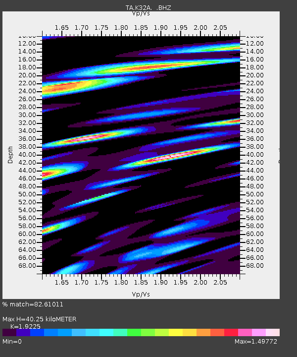
K32A Verdigre, NE, USA - Earthquake Result Viewer

Earthquake location: Near East Coast Of Honshu, Japan
Earthquake latitude/longitude: 37.2/141.2
Earthquake time(UTC): 2011/03/12 (071) 13:15:41 GMT
Earthquake Depth: 38 km
Earthquake Magnitude: 6.1 MB, 5.9 MS, 6.2 MW, 6.1 MW
Earthquake Catalog/Contributor: WHDF/NEIC
Network: TA USArray Transportable Network (new EarthScope stations)
Station: K32A Verdigre, NE, USA
Lat/Lon: 42.66 N/97.97 W
Elevation: 512 m
Distance: 84.0 deg
Az: 39.544 deg
Baz: 316.47 deg
Ray Param: 0.04574993
Estimated Moho Depth: 40.25 km
Estimated Crust Vp/Vs: 1.92
Assumed Crust Vp: 6.498 km/s
Estimated Crust Vs: 3.38 km/s
Estimated Crust Poisson's Ratio: 0.31
Radial Match: 82.61011 %
Radial Bump: 400
Transverse Match: 60.19324 %
Transverse Bump: 400
SOD ConfigId: 356183
Insert Time: 2011-08-20 00:40:06.849 +0000
GWidth: 2.5
Max Bumps: 400
Tol: 0.001

Signal To Noise

ChannelStoNSTALTA
TA:K32A: :BHZ:20110312T13:27:36.775Z7.7968161.3208455E-61.6940832E-7
TA:K32A: :BHN:20110312T13:27:36.775Z3.40132747.264725E-72.13585E-7
TA:K32A: :BHE:20110312T13:27:36.775Z3.20203357.42821E-72.3198415E-7
Arrivals
Ps5.9 SECOND
PpPs18 SECOND
PsPs/PpSs24 SECOND