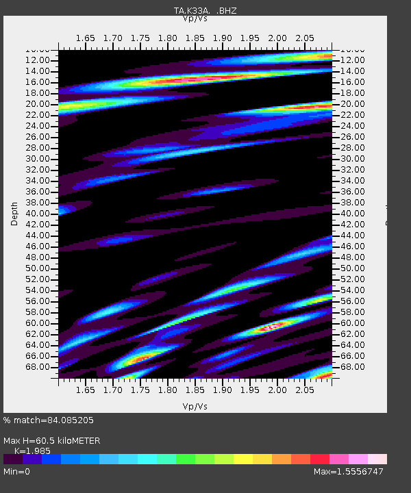
K33A Hardington, NE, USA - Earthquake Result Viewer
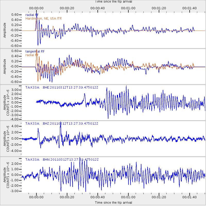
Earthquake location: Near East Coast Of Honshu, Japan
Earthquake latitude/longitude: 37.2/141.2
Earthquake time(UTC): 2011/03/12 (071) 13:15:41 GMT
Earthquake Depth: 38 km
Earthquake Magnitude: 6.1 MB, 5.9 MS, 6.2 MW, 6.1 MW
Earthquake Catalog/Contributor: WHDF/NEIC
Network: TA USArray Transportable Network (new EarthScope stations)
Station: K33A Hardington, NE, USA
Lat/Lon: 42.61 N/97.00 W
Elevation: 507 m
Distance: 84.5 deg
Az: 39.057 deg
Baz: 317.077 deg
Ray Param: 0.045377485
Estimated Moho Depth: 60.5 km
Estimated Crust Vp/Vs: 1.99
Assumed Crust Vp: 6.498 km/s
Estimated Crust Vs: 3.273 km/s
Estimated Crust Poisson's Ratio: 0.33
Radial Match: 84.085205 %
Radial Bump: 400
Transverse Match: 78.759315 %
Transverse Bump: 400
SOD ConfigId: 356183
Insert Time: 2011-08-20 00:41:13.588 +0000
GWidth: 2.5
Max Bumps: 400
Tol: 0.001

Signal To Noise

ChannelStoNSTALTA
TA:K33A: :BHZ:20110312T13:27:39.475012Z5.98048541.4214348E-62.3767882E-7
TA:K33A: :BHN:20110312T13:27:39.475012Z2.17929656.4121826E-72.9423177E-7
TA:K33A: :BHE:20110312T13:27:39.475012Z2.11707578.339766E-73.939286E-7
Arrivals
Ps9.4 SECOND
PpPs27 SECOND
PsPs/PpSs37 SECOND