You are here: Home > Network List > TA - USArray Transportable Network (new EarthScope stations) Stations List
> Station I35A Creekview Farms, Bingham Lake, MN, USA > Earthquake Result Viewer
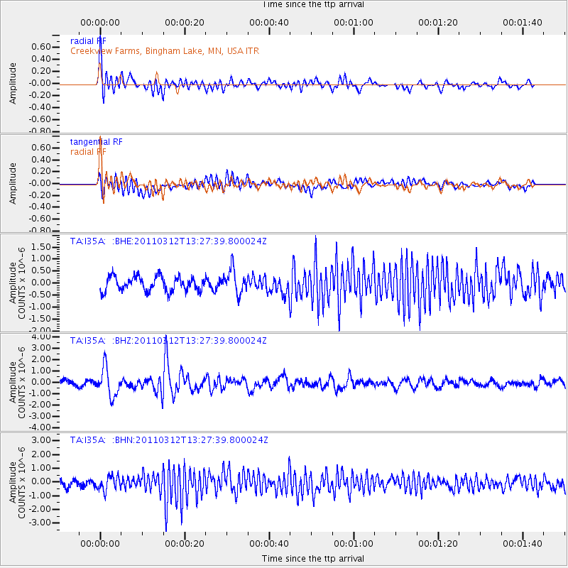
I35A Creekview Farms, Bingham Lake, MN, USA - Earthquake Result Viewer

| Earthquake location: |
Near East Coast Of Honshu, Japan |
| Earthquake latitude/longitude: |
37.2/141.2 |
| Earthquake time(UTC): |
2011/03/12 (071) 13:15:41 GMT |
| Earthquake Depth: |
38 km |
| Earthquake Magnitude: |
6.1 MB, 5.9 MS, 6.2 MW, 6.1 MW |
| Earthquake Catalog/Contributor: |
WHDF/NEIC |
|
| Network: |
TA USArray Transportable Network (new EarthScope stations) |
| Station: |
I35A Creekview Farms, Bingham Lake, MN, USA |
| Lat/Lon: |
43.86 N/94.98 W |
| Elevation: |
428 m |
|
| Distance: |
84.6 deg |
| Az: |
37.116 deg |
| Baz: |
318.27 deg |
| Ray Param: |
0.045328137 |
| Estimated Moho Depth: |
51.75 km |
| Estimated Crust Vp/Vs: |
1.63 |
| Assumed Crust Vp: |
6.53 km/s |
| Estimated Crust Vs: |
4.013 km/s |
| Estimated Crust Poisson's Ratio: |
0.20 |
|
| Radial Match: |
80.98509 % |
| Radial Bump: |
400 |
| Transverse Match: |
68.27671 % |
| Transverse Bump: |
400 |
| SOD ConfigId: |
356183 |
| Insert Time: |
2011-08-20 00:43:30.771 +0000 |
| GWidth: |
2.5 |
| Max Bumps: |
400 |
| Tol: |
0.001 |
|
Signal To Noise
| Channel | StoN | STA | LTA |
| TA:I35A: :BHZ:20110312T13:27:39.800024Z | 5.32941 | 1.2842881E-6 | 2.4098128E-7 |
| TA:I35A: :BHN:20110312T13:27:39.800024Z | 2.4597156 | 5.1768444E-7 | 2.1046516E-7 |
| TA:I35A: :BHE:20110312T13:27:39.800024Z | 1.7242008 | 5.148771E-7 | 2.9861783E-7 |
| Arrivals |
| Ps | 5.1 SECOND |
| PpPs | 20 SECOND |
| PsPs/PpSs | 25 SECOND |


