You are here: Home > Network List > AZ - ANZA Regional Network Stations List
> Station RDM AZ.RDM > Earthquake Result Viewer
RDM AZ.RDM - Earthquake Result Viewer
| Earthquake location: |
Windward Islands |
| Earthquake latitude/longitude: |
15.0/-61.3 |
| Earthquake time(UTC): |
2007/11/29 (333) 19:00:19 GMT |
| Earthquake Depth: |
148 km |
| Earthquake Magnitude: |
6.9 MB, 7.4 MW, 7.4 MW |
| Earthquake Catalog/Contributor: |
WHDF/NEIC |
|
| Network: |
AZ ANZA Regional Network |
| Station: |
RDM AZ.RDM |
| Lat/Lon: |
33.63 N/116.85 W |
| Elevation: |
1365 m |
|
| Distance: |
53.3 deg |
| Az: |
300.885 deg |
| Baz: |
96.22 deg |
| Ray Param: |
0.065672055 |
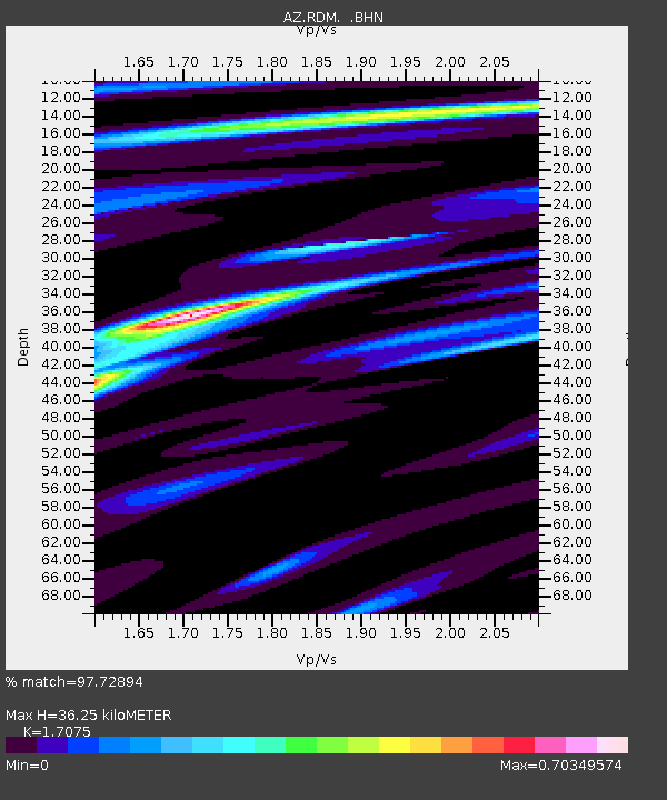
| Estimated Moho Depth: |
36.25 km |
| Estimated Crust Vp/Vs: |
1.71 |
| Assumed Crust Vp: |
6.264 km/s |
| Estimated Crust Vs: |
3.668 km/s |
| Estimated Crust Poisson's Ratio: |
0.24 |
|
| Radial Match: |
97.72894 % |
| Radial Bump: |
286 |
| Transverse Match: |
92.339035 % |
| Transverse Bump: |
400 |
| SOD ConfigId: |
2564 |
| Insert Time: |
2010-02-26 20:32:46.020 +0000 |
| GWidth: |
2.5 |
| Max Bumps: |
400 |
| Tol: |
0.001 |
|

Signal To Noise
| Channel | StoN | STA | LTA |
| AZ:RDM: :BHN:20071129T19:08:52.949011Z | 1.6691846 | 6.6046584E-7 | 3.9568172E-7 |
| AZ:RDM: :BHE:20071129T19:08:52.949011Z | 12.79377 | 3.4596235E-6 | 2.704147E-7 |
| AZ:RDM: :BHZ:20071129T19:08:52.949011Z | 20.386944 | 6.3682755E-6 | 3.1237028E-7 |
| Arrivals |
| Ps | 4.3 SECOND |
| PpPs | 15 SECOND |
| PsPs/PpSs | 19 SECOND |


