You are here: Home > Network List > TA - USArray Transportable Network (new EarthScope stations) Stations List
> Station J38A Wedel Dairy, Riceville, IA, USA > Earthquake Result Viewer
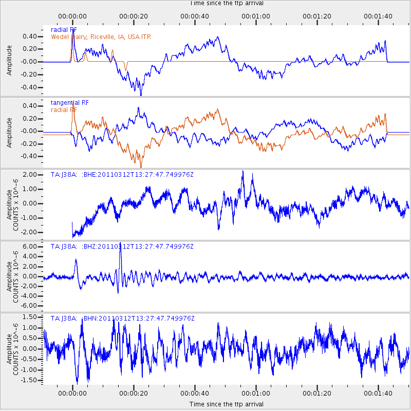
J38A Wedel Dairy, Riceville, IA, USA - Earthquake Result Viewer
*The percent match for this event was below the threshold and hence no stack was calculated.
| Earthquake location: |
Near East Coast Of Honshu, Japan |
| Earthquake latitude/longitude: |
37.2/141.2 |
| Earthquake time(UTC): |
2011/03/12 (071) 13:15:41 GMT |
| Earthquake Depth: |
38 km |
| Earthquake Magnitude: |
6.1 MB, 5.9 MS, 6.2 MW, 6.1 MW |
| Earthquake Catalog/Contributor: |
WHDF/NEIC |
|
| Network: |
TA USArray Transportable Network (new EarthScope stations) |
| Station: |
J38A Wedel Dairy, Riceville, IA, USA |
| Lat/Lon: |
43.32 N/92.48 W |
| Elevation: |
371 m |
|
| Distance: |
86.2 deg |
| Az: |
36.087 deg |
| Baz: |
319.91 deg |
| Ray Param: |
$rayparam |
*The percent match for this event was below the threshold and hence was not used in the summary stack. |
|
| Radial Match: |
52.539032 % |
| Radial Bump: |
400 |
| Transverse Match: |
47.83337 % |
| Transverse Bump: |
400 |
| SOD ConfigId: |
356183 |
| Insert Time: |
2011-08-20 00:52:17.621 +0000 |
| GWidth: |
2.5 |
| Max Bumps: |
400 |
| Tol: |
0.001 |
|
Signal To Noise
| Channel | StoN | STA | LTA |
| TA:J38A: :BHZ:20110312T13:27:47.749976Z | 5.9939795 | 1.510554E-6 | 2.520119E-7 |
| TA:J38A: :BHN:20110312T13:27:47.749976Z | 1.8400738 | 7.659554E-7 | 4.1626342E-7 |
| TA:J38A: :BHE:20110312T13:27:47.749976Z | 1.0817406 | 9.097803E-7 | 8.410337E-7 |
| Arrivals |
| Ps | |
| PpPs | |
| PsPs/PpSs | |


