You are here: Home > Network List > US - United States National Seismic Network Stations List
> Station LONY Lake Ozonia, New York, USA > Earthquake Result Viewer
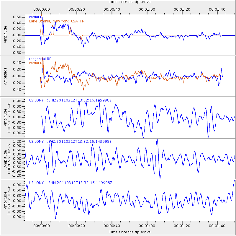
LONY Lake Ozonia, New York, USA - Earthquake Result Viewer
*The percent match for this event was below the threshold and hence no stack was calculated.
| Earthquake location: |
Gulf Of California |
| Earthquake latitude/longitude: |
25.2/-109.8 |
| Earthquake time(UTC): |
2011/03/12 (071) 13:25:59 GMT |
| Earthquake Depth: |
13 km |
| Earthquake Magnitude: |
5.5 MW, 5.2 MS, 5.3 MB |
| Earthquake Catalog/Contributor: |
WHDF/NEIC |
|
| Network: |
US United States National Seismic Network |
| Station: |
LONY Lake Ozonia, New York, USA |
| Lat/Lon: |
44.62 N/74.58 W |
| Elevation: |
440 m |
|
| Distance: |
34.4 deg |
| Az: |
46.792 deg |
| Baz: |
247.6 deg |
| Ray Param: |
$rayparam |
*The percent match for this event was below the threshold and hence was not used in the summary stack. |
|
| Radial Match: |
57.791378 % |
| Radial Bump: |
400 |
| Transverse Match: |
58.3883 % |
| Transverse Bump: |
400 |
| SOD ConfigId: |
356183 |
| Insert Time: |
2011-08-20 01:38:58.158 +0000 |
| GWidth: |
2.5 |
| Max Bumps: |
400 |
| Tol: |
0.001 |
|
Signal To Noise
| Channel | StoN | STA | LTA |
| US:LONY: :BHZ:20110312T13:32:16.149998Z | 1.3265558 | 5.8465235E-7 | 4.4072954E-7 |
| US:LONY: :BHN:20110312T13:32:16.149998Z | 0.96364206 | 3.8044058E-7 | 3.9479448E-7 |
| US:LONY: :BHE:20110312T13:32:16.149998Z | 1.4977175 | 6.3471043E-7 | 4.2378517E-7 |
| Arrivals |
| Ps | |
| PpPs | |
| PsPs/PpSs | |


