You are here: Home > Network List > TA - USArray Transportable Network (new EarthScope stations) Stations List
> Station L35A Bielow Farm, Ricketts, IA, USA > Earthquake Result Viewer
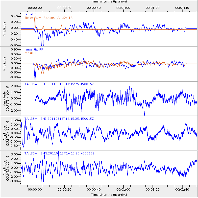
L35A Bielow Farm, Ricketts, IA, USA - Earthquake Result Viewer
*The percent match for this event was below the threshold and hence no stack was calculated.
| Earthquake location: |
Near East Coast Of Honshu, Japan |
| Earthquake latitude/longitude: |
38.8/142.5 |
| Earthquake time(UTC): |
2011/03/12 (071) 14:03:31 GMT |
| Earthquake Depth: |
35 km |
| Earthquake Magnitude: |
5.8 MB, 5.3 MS, 5.6 MW |
| Earthquake Catalog/Contributor: |
WHDF/NEIC |
|
| Network: |
TA USArray Transportable Network (new EarthScope stations) |
| Station: |
L35A Bielow Farm, Ricketts, IA, USA |
| Lat/Lon: |
42.11 N/95.54 W |
| Elevation: |
410 m |
|
| Distance: |
83.7 deg |
| Az: |
39.455 deg |
| Baz: |
318.131 deg |
| Ray Param: |
$rayparam |
*The percent match for this event was below the threshold and hence was not used in the summary stack. |
|
| Radial Match: |
53.207996 % |
| Radial Bump: |
400 |
| Transverse Match: |
45.045567 % |
| Transverse Bump: |
400 |
| SOD ConfigId: |
356183 |
| Insert Time: |
2011-08-20 02:38:11.269 +0000 |
| GWidth: |
2.5 |
| Max Bumps: |
400 |
| Tol: |
0.001 |
|
Signal To Noise
| Channel | StoN | STA | LTA |
| TA:L35A: :BHZ:20110312T14:15:25.450015Z | 0.8975111 | 5.5955655E-7 | 6.2345356E-7 |
| TA:L35A: :BHN:20110312T14:15:25.450015Z | 2.3927677 | 1.1938697E-6 | 4.989493E-7 |
| TA:L35A: :BHE:20110312T14:15:25.450015Z | 1.0238658 | 7.5258816E-7 | 7.350458E-7 |
| Arrivals |
| Ps | |
| PpPs | |
| PsPs/PpSs | |


