You are here: Home > Network List > AZ - ANZA Regional Network Stations List
> Station RDM AZ.RDM > Earthquake Result Viewer
RDM AZ.RDM - Earthquake Result Viewer
| Earthquake location: |
East Of Kuril Islands |
| Earthquake latitude/longitude: |
46.2/154.5 |
| Earthquake time(UTC): |
2007/01/13 (013) 04:23:21 GMT |
| Earthquake Depth: |
10 km |
| Earthquake Magnitude: |
7.3 MB, 8.2 MS, 8.1 MW, 7.9 MW |
| Earthquake Catalog/Contributor: |
WHDF/NEIC |
|
| Network: |
AZ ANZA Regional Network |
| Station: |
RDM AZ.RDM |
| Lat/Lon: |
33.63 N/116.85 W |
| Elevation: |
1365 m |
|
| Distance: |
65.7 deg |
| Az: |
66.182 deg |
| Baz: |
310.45 deg |
| Ray Param: |
0.058067717 |
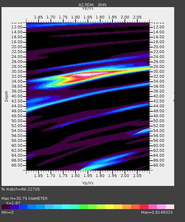
| Estimated Moho Depth: |
30.75 km |
| Estimated Crust Vp/Vs: |
1.87 |
| Assumed Crust Vp: |
6.264 km/s |
| Estimated Crust Vs: |
3.35 km/s |
| Estimated Crust Poisson's Ratio: |
0.30 |
|
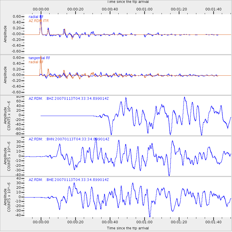
| Radial Match: |
98.22705 % |
| Radial Bump: |
207 |
| Transverse Match: |
87.524475 % |
| Transverse Bump: |
400 |
| SOD ConfigId: |
2564 |
| Insert Time: |
2010-02-26 20:33:35.231 +0000 |
| GWidth: |
2.5 |
| Max Bumps: |
400 |
| Tol: |
0.001 |
|
Signal To Noise
| Channel | StoN | STA | LTA |
| AZ:RDM: :BHN:20070113T04:33:34.899014Z | 5.0685496 | 8.511761E-7 | 1.6793287E-7 |
| AZ:RDM: :BHE:20070113T04:33:34.899014Z | 4.073634 | 9.3901343E-7 | 2.3051001E-7 |
| AZ:RDM: :BHZ:20070113T04:33:34.899014Z | 11.370139 | 2.4403193E-6 | 2.1462529E-7 |
| Arrivals |
| Ps | 4.4 SECOND |
| PpPs | 14 SECOND |
| PsPs/PpSs | 18 SECOND |


