You are here: Home > Network List > US - United States National Seismic Network Stations List
> Station AGMN Agassiz National Wildlife Refuge, Minnesota, USA > Earthquake Result Viewer
AGMN Agassiz National Wildlife Refuge, Minnesota, USA - Earthquake Result Viewer
*The percent match for this event was below the threshold and hence no stack was calculated.
| Earthquake location: |
Near East Coast Of Honshu, Japan |
| Earthquake latitude/longitude: |
35.8/141.7 |
| Earthquake time(UTC): |
2011/03/12 (071) 14:35:01 GMT |
| Earthquake Depth: |
35 km |
| Earthquake Magnitude: |
5.6 MB |
| Earthquake Catalog/Contributor: |
WHDF/NEIC |
|
| Network: |
US United States National Seismic Network |
| Station: |
AGMN Agassiz National Wildlife Refuge, Minnesota, USA |
| Lat/Lon: |
48.30 N/95.86 W |
| Elevation: |
351 m |
|
| Distance: |
81.9 deg |
| Az: |
34.685 deg |
| Baz: |
316.133 deg |
| Ray Param: |
$rayparam |
*The percent match for this event was below the threshold and hence was not used in the summary stack. |
|
| Radial Match: |
34.263016 % |
| Radial Bump: |
400 |
| Transverse Match: |
36.25394 % |
| Transverse Bump: |
400 |
| SOD ConfigId: |
356183 |
| Insert Time: |
2011-08-20 04:06:58.180 +0000 |
| GWidth: |
2.5 |
| Max Bumps: |
400 |
| Tol: |
0.001 |
|
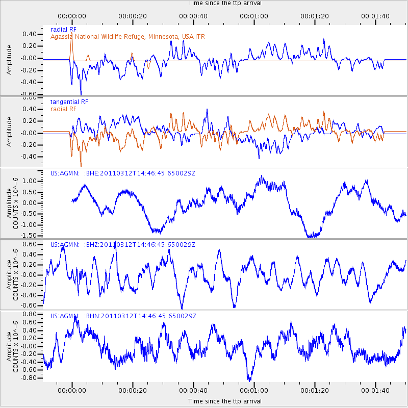
Signal To Noise
| Channel | StoN | STA | LTA |
| US:AGMN: :BHZ:20110312T14:46:45.650029Z | 0.3665654 | 1.1012607E-7 | 3.004268E-7 |
| US:AGMN: :BHN:20110312T14:46:45.650029Z | 2.1601238 | 5.329657E-7 | 2.4672923E-7 |
| US:AGMN: :BHE:20110312T14:46:45.650029Z | 2.528812 | 9.8554E-7 | 3.8972453E-7 |
| Arrivals |
| Ps | |
| PpPs | |
| PsPs/PpSs | |


