You are here: Home > Network List > KN - Kyrgyz Seismic Telemetry Network Stations List
> Station CHM KN.CHM > Earthquake Result Viewer
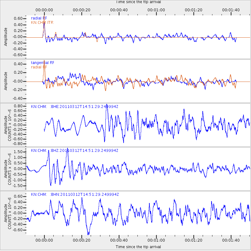
CHM KN.CHM - Earthquake Result Viewer
*The percent match for this event was below the threshold and hence no stack was calculated.
| Earthquake location: |
Near East Coast Of Honshu, Japan |
| Earthquake latitude/longitude: |
39.5/142.4 |
| Earthquake time(UTC): |
2011/03/12 (071) 14:43:10 GMT |
| Earthquake Depth: |
35 km |
| Earthquake Magnitude: |
5.7 MB, 5.5 MS, 5.8 MW |
| Earthquake Catalog/Contributor: |
WHDF/NEIC |
|
| Network: |
KN Kyrgyz Seismic Telemetry Network |
| Station: |
CHM KN.CHM |
| Lat/Lon: |
43.00 N/74.75 E |
| Elevation: |
655 m |
|
| Distance: |
49.8 deg |
| Az: |
297.247 deg |
| Baz: |
69.728 deg |
| Ray Param: |
$rayparam |
*The percent match for this event was below the threshold and hence was not used in the summary stack. |
|
| Radial Match: |
65.54701 % |
| Radial Bump: |
400 |
| Transverse Match: |
66.76752 % |
| Transverse Bump: |
400 |
| SOD ConfigId: |
356183 |
| Insert Time: |
2011-08-20 04:37:54.739 +0000 |
| GWidth: |
2.5 |
| Max Bumps: |
400 |
| Tol: |
0.001 |
|
Signal To Noise
| Channel | StoN | STA | LTA |
| KN:CHM: :BHZ:20110312T14:51:29.249994Z | 5.081988 | 8.127301E-7 | 1.5992366E-7 |
| KN:CHM: :BHN:20110312T14:51:29.249994Z | 1.8168958 | 2.273038E-7 | 1.2510557E-7 |
| KN:CHM: :BHE:20110312T14:51:29.249994Z | 2.0504353 | 4.2128303E-7 | 2.0546031E-7 |
| Arrivals |
| Ps | |
| PpPs | |
| PsPs/PpSs | |


