You are here: Home > Network List > KN - Kyrgyz Seismic Telemetry Network Stations List
> Station TKM2 KN.TKM2 > Earthquake Result Viewer
TKM2 KN.TKM2 - Earthquake Result Viewer
*The percent match for this event was below the threshold and hence no stack was calculated.
| Earthquake location: |
Near East Coast Of Honshu, Japan |
| Earthquake latitude/longitude: |
39.5/142.4 |
| Earthquake time(UTC): |
2011/03/12 (071) 14:43:10 GMT |
| Earthquake Depth: |
35 km |
| Earthquake Magnitude: |
5.7 MB, 5.5 MS, 5.8 MW |
| Earthquake Catalog/Contributor: |
WHDF/NEIC |
|
| Network: |
KN Kyrgyz Seismic Telemetry Network |
| Station: |
TKM2 KN.TKM2 |
| Lat/Lon: |
42.92 N/75.60 E |
| Elevation: |
2020 m |
|
| Distance: |
49.2 deg |
| Az: |
296.871 deg |
| Baz: |
70.057 deg |
| Ray Param: |
$rayparam |
*The percent match for this event was below the threshold and hence was not used in the summary stack. |
|
| Radial Match: |
73.2651 % |
| Radial Bump: |
400 |
| Transverse Match: |
70.527695 % |
| Transverse Bump: |
400 |
| SOD ConfigId: |
356183 |
| Insert Time: |
2011-08-20 04:40:39.977 +0000 |
| GWidth: |
2.5 |
| Max Bumps: |
400 |
| Tol: |
0.001 |
|
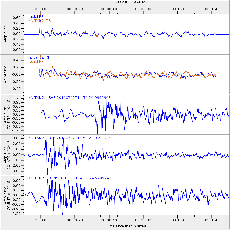
Signal To Noise
| Channel | StoN | STA | LTA |
| KN:TKM2: :BHZ:20110312T14:51:24.999994Z | 7.17373 | 1.3500307E-6 | 1.8819091E-7 |
| KN:TKM2: :BHN:20110312T14:51:24.999994Z | 2.4076757 | 3.9723548E-7 | 1.6498711E-7 |
| KN:TKM2: :BHE:20110312T14:51:24.999994Z | 2.4275146 | 5.418898E-7 | 2.2322823E-7 |
| Arrivals |
| Ps | |
| PpPs | |
| PsPs/PpSs | |


