You are here: Home > Network List > TA - USArray Transportable Network (new EarthScope stations) Stations List
> Station M33A Taylor Creek Farms, Clarkson, NE, USA > Earthquake Result Viewer
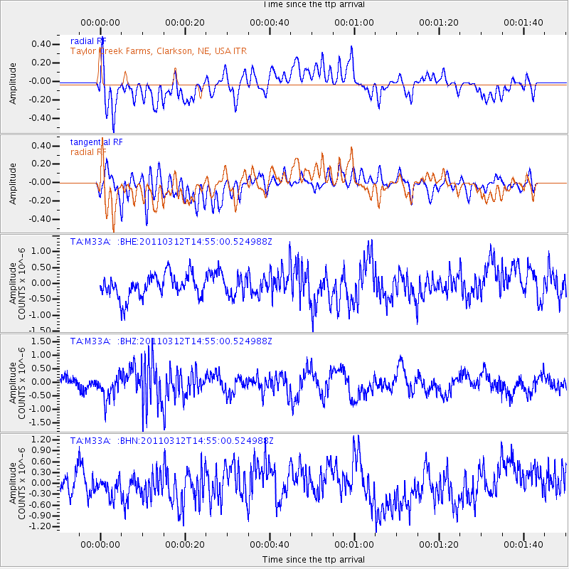
M33A Taylor Creek Farms, Clarkson, NE, USA - Earthquake Result Viewer
*The percent match for this event was below the threshold and hence no stack was calculated.
| Earthquake location: |
Near East Coast Of Honshu, Japan |
| Earthquake latitude/longitude: |
39.5/142.4 |
| Earthquake time(UTC): |
2011/03/12 (071) 14:43:10 GMT |
| Earthquake Depth: |
35 km |
| Earthquake Magnitude: |
5.7 MB, 5.5 MS, 5.8 MW |
| Earthquake Catalog/Contributor: |
WHDF/NEIC |
|
| Network: |
TA USArray Transportable Network (new EarthScope stations) |
| Station: |
M33A Taylor Creek Farms, Clarkson, NE, USA |
| Lat/Lon: |
41.57 N/97.19 W |
| Elevation: |
503 m |
|
| Distance: |
82.8 deg |
| Az: |
40.711 deg |
| Baz: |
317.707 deg |
| Ray Param: |
$rayparam |
*The percent match for this event was below the threshold and hence was not used in the summary stack. |
|
| Radial Match: |
49.279587 % |
| Radial Bump: |
400 |
| Transverse Match: |
58.111687 % |
| Transverse Bump: |
400 |
| SOD ConfigId: |
356183 |
| Insert Time: |
2011-08-20 05:07:06.394 +0000 |
| GWidth: |
2.5 |
| Max Bumps: |
400 |
| Tol: |
0.001 |
|
Signal To Noise
| Channel | StoN | STA | LTA |
| TA:M33A: :BHZ:20110312T14:55:00.524988Z | 1.8871819 | 4.62942E-7 | 2.4530863E-7 |
| TA:M33A: :BHN:20110312T14:55:00.524988Z | 0.91519094 | 3.4906284E-7 | 3.8140988E-7 |
| TA:M33A: :BHE:20110312T14:55:00.524988Z | 0.8094936 | 2.8740246E-7 | 3.550398E-7 |
| Arrivals |
| Ps | |
| PpPs | |
| PsPs/PpSs | |


