You are here: Home > Network List > TA - USArray Transportable Network (new EarthScope stations) Stations List
> Station J34A George, IA, USA > Earthquake Result Viewer
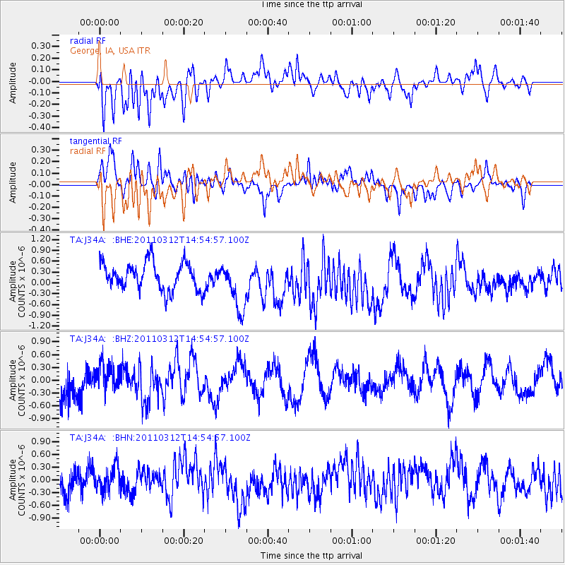
J34A George, IA, USA - Earthquake Result Viewer
*The percent match for this event was below the threshold and hence no stack was calculated.
| Earthquake location: |
Near East Coast Of Honshu, Japan |
| Earthquake latitude/longitude: |
39.5/142.4 |
| Earthquake time(UTC): |
2011/03/12 (071) 14:43:10 GMT |
| Earthquake Depth: |
35 km |
| Earthquake Magnitude: |
5.7 MB, 5.5 MS, 5.8 MW |
| Earthquake Catalog/Contributor: |
WHDF/NEIC |
|
| Network: |
TA USArray Transportable Network (new EarthScope stations) |
| Station: |
J34A George, IA, USA |
| Lat/Lon: |
43.28 N/95.96 W |
| Elevation: |
432 m |
|
| Distance: |
82.2 deg |
| Az: |
38.87 deg |
| Baz: |
318.299 deg |
| Ray Param: |
$rayparam |
*The percent match for this event was below the threshold and hence was not used in the summary stack. |
|
| Radial Match: |
38.291176 % |
| Radial Bump: |
400 |
| Transverse Match: |
51.087074 % |
| Transverse Bump: |
400 |
| SOD ConfigId: |
356183 |
| Insert Time: |
2011-08-20 05:08:12.424 +0000 |
| GWidth: |
2.5 |
| Max Bumps: |
400 |
| Tol: |
0.001 |
|
Signal To Noise
| Channel | StoN | STA | LTA |
| TA:J34A: :BHZ:20110312T14:54:57.100Z | 1.0244956 | 3.3420912E-7 | 3.2621818E-7 |
| TA:J34A: :BHN:20110312T14:54:57.100Z | 1.2283798 | 3.0408893E-7 | 2.4755286E-7 |
| TA:J34A: :BHE:20110312T14:54:57.100Z | 1.830053 | 6.928382E-7 | 3.7858916E-7 |
| Arrivals |
| Ps | |
| PpPs | |
| PsPs/PpSs | |


