You are here: Home > Network List > TA - USArray Transportable Network (new EarthScope stations) Stations List
> Station D34A Park Rapids, MN, USA > Earthquake Result Viewer
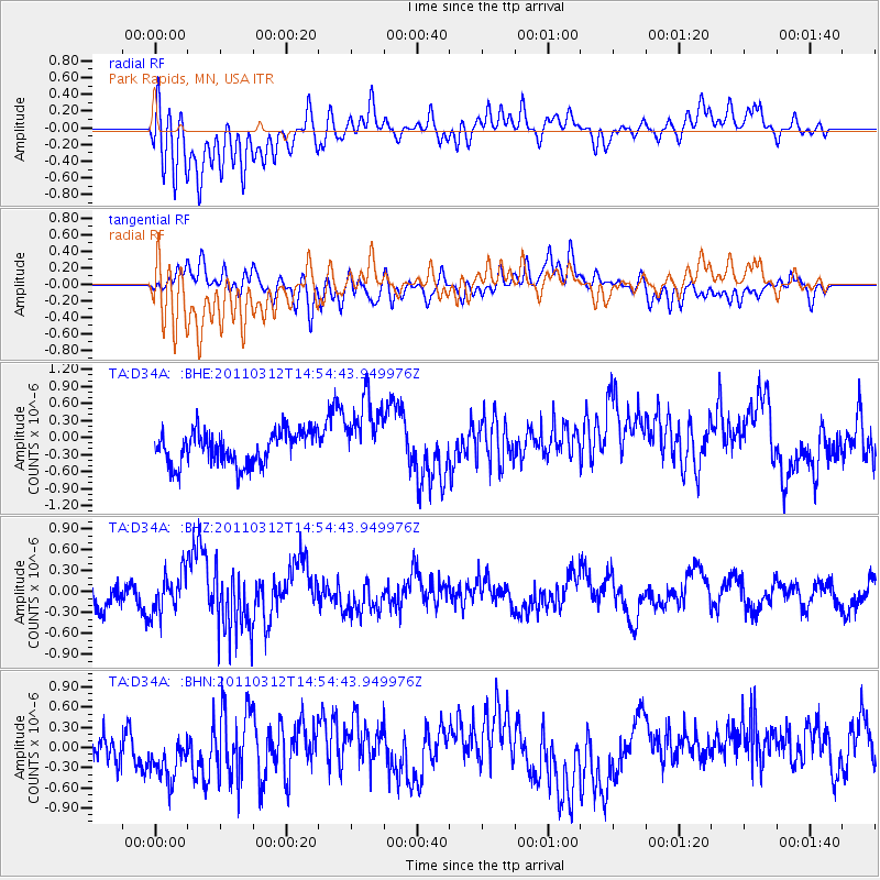
D34A Park Rapids, MN, USA - Earthquake Result Viewer
*The percent match for this event was below the threshold and hence no stack was calculated.
| Earthquake location: |
Near East Coast Of Honshu, Japan |
| Earthquake latitude/longitude: |
39.5/142.4 |
| Earthquake time(UTC): |
2011/03/12 (071) 14:43:10 GMT |
| Earthquake Depth: |
35 km |
| Earthquake Magnitude: |
5.7 MB, 5.5 MS, 5.8 MW |
| Earthquake Catalog/Contributor: |
WHDF/NEIC |
|
| Network: |
TA USArray Transportable Network (new EarthScope stations) |
| Station: |
D34A Park Rapids, MN, USA |
| Lat/Lon: |
47.09 N/95.20 W |
| Elevation: |
476 m |
|
| Distance: |
79.7 deg |
| Az: |
35.904 deg |
| Baz: |
318.372 deg |
| Ray Param: |
$rayparam |
*The percent match for this event was below the threshold and hence was not used in the summary stack. |
|
| Radial Match: |
58.881844 % |
| Radial Bump: |
400 |
| Transverse Match: |
59.12516 % |
| Transverse Bump: |
400 |
| SOD ConfigId: |
356183 |
| Insert Time: |
2011-08-20 05:10:37.135 +0000 |
| GWidth: |
2.5 |
| Max Bumps: |
400 |
| Tol: |
0.001 |
|
Signal To Noise
| Channel | StoN | STA | LTA |
| TA:D34A: :BHZ:20110312T14:54:43.949976Z | 1.8605809 | 2.813184E-7 | 1.5119923E-7 |
| TA:D34A: :BHN:20110312T14:54:43.949976Z | 1.6710734 | 4.2085216E-7 | 2.518454E-7 |
| TA:D34A: :BHE:20110312T14:54:43.949976Z | 2.1539645 | 6.266047E-7 | 2.9090762E-7 |
| Arrivals |
| Ps | |
| PpPs | |
| PsPs/PpSs | |


