You are here: Home > Network List > CI - Caltech Regional Seismic Network Stations List
> Station GMR Granite Mountains Research Center > Earthquake Result Viewer
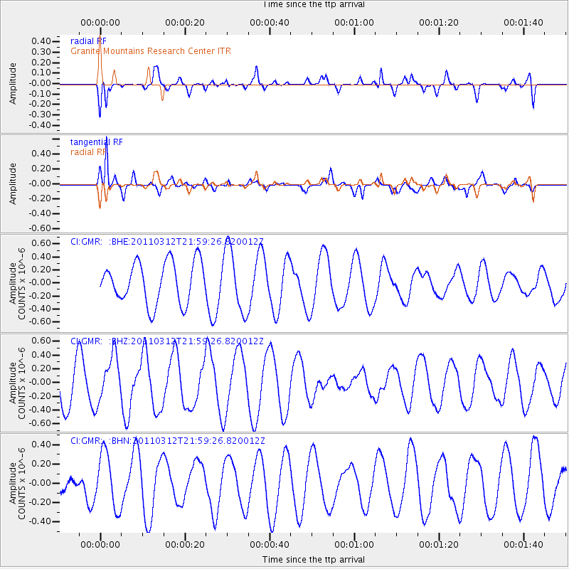
GMR Granite Mountains Research Center - Earthquake Result Viewer
*The percent match for this event was below the threshold and hence no stack was calculated.
| Earthquake location: |
Near East Coast Of Honshu, Japan |
| Earthquake latitude/longitude: |
39.6/142.6 |
| Earthquake time(UTC): |
2011/03/12 (071) 21:48:09 GMT |
| Earthquake Depth: |
26 km |
| Earthquake Magnitude: |
5.5 MB, 5.3 MS, 5.6 MW |
| Earthquake Catalog/Contributor: |
WHDF/NEIC |
|
| Network: |
CI Caltech Regional Seismic Network |
| Station: |
GMR Granite Mountains Research Center |
| Lat/Lon: |
34.78 N/115.66 W |
| Elevation: |
1326 m |
|
| Distance: |
76.6 deg |
| Az: |
55.911 deg |
| Baz: |
308.991 deg |
| Ray Param: |
$rayparam |
*The percent match for this event was below the threshold and hence was not used in the summary stack. |
|
| Radial Match: |
75.83068 % |
| Radial Bump: |
400 |
| Transverse Match: |
93.38788 % |
| Transverse Bump: |
400 |
| SOD ConfigId: |
356183 |
| Insert Time: |
2011-08-20 06:22:30.010 +0000 |
| GWidth: |
2.5 |
| Max Bumps: |
400 |
| Tol: |
0.001 |
|
Signal To Noise
| Channel | StoN | STA | LTA |
| CI:GMR: :BHZ:20110312T21:59:26.820012Z | 0.79906267 | 3.312836E-7 | 4.1459026E-7 |
| CI:GMR: :BHN:20110312T21:59:26.820012Z | 1.791508 | 2.9872206E-7 | 1.6674336E-7 |
| CI:GMR: :BHE:20110312T21:59:26.820012Z | 1.5731927 | 4.935368E-7 | 3.137167E-7 |
| Arrivals |
| Ps | |
| PpPs | |
| PsPs/PpSs | |


